
Carte topographique Reno
Carte interactive
Cliquez sur la carte pour afficher l’altitude.
À propos de cette carte
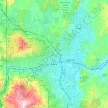
Nom : Carte topographique Reno, altitude, relief.
Lieu : Reno, Washoe County, Nevada, United States of America (39.39243 -120.00237 39.72344 -119.69935)
Altitude moyenne : 1 650 m
Altitude minimum : 1 316 m
Altitude maximum : 3 010 m
Reno is just east of the Sierra Nevada, on the western edge of the Great Basin at an elevation of about 4,400 feet (1,300 m) above sea level. Numerous faults exist throughout the region. Most of these are normal (vertical motion) faults associated with the uplift of the various mountain ranges, including the Sierra Nevada.