
Carte topographique Massif Central
Carte interactive
Cliquez sur la carte pour afficher l’altitude.
À propos de cette carte
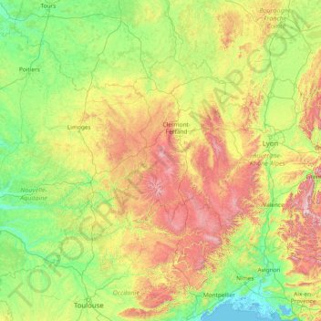
Nom : Carte topographique Massif Central, altitude, relief.
Altitude moyenne : 367 m
Altitude minimum : -3 m
Altitude maximum : 2 060 m
The Massif Central is an old massif, formed during the Variscan orogeny, consisting mostly of granitic and metamorphic rocks. It was powerfully raised and made to look geologically younger in the eastern section by the uplift of the Alps during the Paleogene period and in the southern section by the uplift of the Pyrenees. The massif thus presents a strongly asymmetrical elevation profile with highlands in the south and in the east (Cévennes) dominating the valley of the Rhône and the plains of Languedoc and by contrast, the less elevated region of Limousin in the northwest.