
Carte topographique Zhaotong
Carte interactive
Cliquez sur la carte pour afficher l’altitude.
Zhaotong
Influenced by the low latitude and moderate elevation, Zhaotong has a temperate subtropical highland climate (Köppen Cwb), with cool, dry winters, and warm, humid summers. Temperatures frequently drop below freezing at night in winter, though the days warm up to around 10 °C (50 °F). Conversely, in summer, average highs rise to 25 °C (77 °F). A great majority of the year's rainfall occurs from May to September.
À propos de cette carte
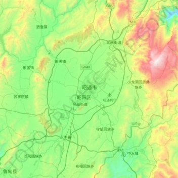
Nom : Carte topographique Zhaotong, altitude, relief.
Lieu : Zhaotong, Zhaoyang District, Zhaotong City, Yunnan, China (27.17767 103.55443 27.49767 103.87443)
Altitude moyenne : 2 071 m
Altitude minimum : 1 585 m
Altitude maximum : 3 134 m