
Carte topographique Nelson
Carte interactive
Cliquez sur la carte pour afficher l’altitude.
À propos de cette carte
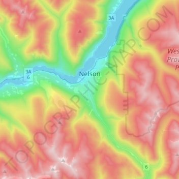
Nom : Carte topographique Nelson, altitude, relief.
Altitude moyenne : 1 325 m
Altitude minimum : 526 m
Altitude maximum : 2 190 m
Autres cartes topographiques
Cliquez sur une carte pour visualiser sa topographie, son altitude et son relief.
Winlaw
Canada > British Columbia > Regional District of Central Kootenay > Area H (The Slocan Valley)
Winlaw, Area H (The Slocan Valley), Regional District of Central Kootenay, British Columbia, V0G 2J0, Canada
Altitude moyenne : 694 m
Slocan
Canada > British Columbia > Regional District of Central Kootenay
Slocan, Regional District of Central Kootenay, British Columbia, V0G 2C0, Canada
Altitude moyenne : 665 m
Stoney Creek
Canada > British Columbia > Regional District of Central Kootenay > Area K (The Arrow Lakes)
Stoney Creek, Area K (The Arrow Lakes), Regional District of Central Kootenay, British Columbia, Canada
Altitude moyenne : 1 295 m
Creston
Canada > British Columbia > Regional District of Central Kootenay
Creston, Regional District of Central Kootenay, British Columbia, Canada
Altitude moyenne : 738 m
Kitchener
Canada > British Columbia > Regional District of Central Kootenay > Area B > Kitchener
Kitchener, Area B, Regional District of Central Kootenay, British Columbia, Canada
Altitude moyenne : 925 m
Goatfell
Canada > British Columbia > Regional District of Central Kootenay > Area B
Goatfell, Area B, Regional District of Central Kootenay, British Columbia, Canada
Altitude moyenne : 975 m
Castlegar
Canada > British Columbia > Regional District of Central Kootenay
Castlegar, Regional District of Central Kootenay, British Columbia, Canada
Altitude moyenne : 831 m