
Carte topographique Door County
Carte interactive
Cliquez sur la carte pour afficher l’altitude.
À propos de cette carte
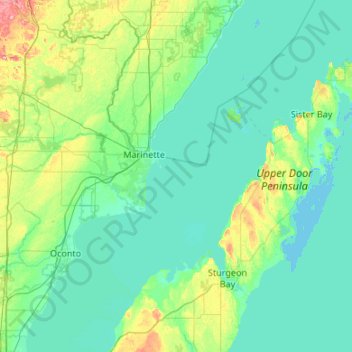
Nom : Carte topographique Door County, altitude, relief.
Lieu : Door County, Wisconsin, United States of America (44.67496 -87.73686 45.42985 -86.76396)
Altitude moyenne : 191 m
Altitude minimum : 172 m
Altitude maximum : 315 m
The 102 ft high Brussels Hill (44°45′06″N 87°35′27″W / 44.75166°N 87.59093°W / 44.75166; -87.59093 (Brussels Hill), elevation 851 feet) is the highest point in the county. The nearby Red Hill Woods is the largest remaining maple–beech forest in the area.
Autres cartes topographiques
Cliquez sur une carte pour visualiser sa topographie, son altitude et son relief.
Waukesha County
United States of America > Wisconsin
Waukesha County, Wisconsin, United States of America
Altitude moyenne : 272 m
Gays Mills
United States of America > Wisconsin > Gays Mills
Gays Mills, Crawford County, Wisconsin, United States of America
Altitude moyenne : 272 m