Géolocaliser

Carte topographique Mount Colong

Cliquez sur la carte pour afficher l’altitude.

À propos de cette carte

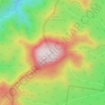
Nom : Carte topographique Mount Colong, altitude, relief.

Lieu : Mount Colong, Wollondilly Shire Council, New South Wales, Australia (-34.12380 150.14268 -34.12370 150.14278)

Altitude moyenne : 761 m

Altitude minimum : 497 m

Altitude maximum : 1 041 m

Autres cartes topographiques

Cliquez sur une carte pour visualiser sa topographie, son altitude et son relief.

Sydney

Australia > New South Wales

Sydney's topography is characterized by a diverse landscape that seamlessly blends coastal features with inland plateaus. The city is divided into two primary regions: the relatively flat Cumberland Plain to the south and west of Sydney Harbour, and the elevated Hornsby Plateau to the north. The Cumberland…

Altitude moyenne : 53 m

Newcastle

Australia > New South Wales > Newcastle

Altitude moyenne : 5 m

Ocean Shores

Australia > New South Wales

Altitude moyenne : 12 m

Port Macquarie

Australia > New South Wales

Altitude moyenne : 5 m

Central Coast Council

Australia > New South Wales

Altitude moyenne : 103 m

Epping

Australia > New South Wales

Altitude moyenne : 96 m

Sydney

Australia > New South Wales > Sydney

Altitude moyenne : 23 m

Picton

Australia > New South Wales

Altitude moyenne : 227 m

Katoomba

Australia > New South Wales

Altitude moyenne : 904 m

Parramatta

Australia > New South Wales

Altitude moyenne : 22 m

Northern Beaches

Australia > New South Wales > Sydney

Altitude moyenne : 67 m

Bowral

Australia > New South Wales

Altitude moyenne : 690 m

Orange

Australia > New South Wales

Orange is a city in the Central Tablelands region of New South Wales, Australia. It is 254 km (158 mi) west of the state capital, Sydney [206 km (128 mi) on a great circle], at an altitude of 862 metres (2,828 ft). Orange had an estimated urban population of 40,493 as of June 2018 making the city a significant…

Altitude moyenne : 852 m

Byron Bay

Australia > New South Wales

Byron Bay, located in northeastern New South Wales, Australia, is characterized by diverse topography shaped by its geological history. The town is part of the erosion caldera of the ancient Tweed Volcano, which erupted approximately 23 million years ago, resulting in the rich volcanic soils that define the…

Altitude moyenne : 7 m

Redfern

Australia > New South Wales

Altitude moyenne : 30 m

Lithgow City Council

Australia > New South Wales

Altitude moyenne : 713 m

North Sydney

Australia > New South Wales > Sydney

Altitude moyenne : 50 m

Banora Point

Australia > New South Wales

Altitude moyenne : 17 m

Woy Woy

Australia > New South Wales

Altitude moyenne : 35 m

Myocum

Australia > New South Wales

Altitude moyenne : 24 m

Armidale

Australia > New South Wales

Altitude moyenne : 1 036 m

Mullumbimby

Australia > New South Wales

Altitude moyenne : 29 m

Bombala

Australia > New South Wales

Altitude moyenne : 775 m

Mudgee

Australia > New South Wales

Altitude moyenne : 535 m

Illawarra

Australia > New South Wales

Altitude moyenne : 234 m

Blue Mountains

Australia > New South Wales

A sandstone plateau dominated by a landscape of endless eucalyptus forests, the Blue Mountains are located at the top of a 470-million-year-old quartzite. In the Permian period, a shallow sea covered the region, when rivers brought shales, siltstones and mudstones. Then during the Mesozoic period, rivers…

Altitude moyenne : 566 m

Hargraves

Australia > New South Wales

Altitude moyenne : 685 m

Breeza

Australia > New South Wales

Altitude moyenne : 318 m

Taylors Arm

Australia > New South Wales

Altitude moyenne : 102 m

Singleton Council

Australia > New South Wales

Altitude moyenne : 238 m

Goulburn

Australia > New South Wales

Owing to its elevation, Goulburn has an oceanic climate (Cfb) with warm summers and cool winters; with a high diurnal range. Its climate is variable much of the year, though generally dry with maximum temperatures ranging from 11.8 °C (53.2 °F) in July to 28.3 °C (82.9 °F) in January. Rainfall is…

Altitude moyenne : 666 m

Mittagong

Australia > New South Wales

Altitude moyenne : 672 m

Casino

Australia > New South Wales

Altitude moyenne : 32 m

Centennial Park

Australia > New South Wales > Sydney

Altitude moyenne : 51 m

Shoal Bay

Australia > New South Wales

Altitude moyenne : 16 m

Wyong

Australia > New South Wales

Altitude moyenne : 9 m

Fortis Creek

Australia > New South Wales

Altitude moyenne : 88 m

Denman

Australia > New South Wales

Altitude moyenne : 164 m

Manly

Australia > New South Wales

Altitude moyenne : 17 m

Taree

Australia > New South Wales

Altitude moyenne : 17 m

King Creek

Australia > New South Wales > Wauchope > King Creek

Altitude moyenne : 6 m

Perisher Valley

Australia > New South Wales

Altitude moyenne : 1 704 m

Bellevue Hill

Australia > New South Wales > Sydney

Altitude moyenne : 36 m

Patonga

Australia > New South Wales

Altitude moyenne : 53 m

Yerrinbool

Australia > New South Wales

Altitude moyenne : 468 m

Lismore

Australia > New South Wales

Altitude moyenne : 23 m

Heron Island

Australia > New South Wales

Altitude moyenne : 1 160 m

Burrinjuck

Australia > New South Wales

Altitude moyenne : 543 m

Budawang Range

Australia > New South Wales

The highest mountain in the range is Mount Budawang that has an elevation of 1,129 metres (3,704 ft) above sea level.

Altitude moyenne : 484 m

Torrington

Australia > New South Wales

Altitude moyenne : 936 m

Wellington

Australia > New South Wales

Altitude moyenne : 321 m

Jerangle

Australia > New South Wales

Altitude moyenne : 1 057 m

Sofala

Australia > New South Wales

Altitude moyenne : 747 m

Hunter Valley

Australia > New South Wales

Altitude moyenne : 353 m

Bomaderry

Australia > New South Wales > Bomaderry

Altitude moyenne : 18 m

Glenbrook

Australia > New South Wales

Altitude moyenne : 168 m

Wingham

Australia > New South Wales

Altitude moyenne : 47 m

Barrington Tops

Australia > New South Wales

Altitude moyenne : 1 107 m

Chatswood

Australia > New South Wales

Altitude moyenne : 81 m

Moss Vale

Australia > New South Wales

Altitude moyenne : 673 m

Camden Council

Australia > New South Wales

Altitude moyenne : 90 m

Glenmore Park

Australia > New South Wales > Sydney

Altitude moyenne : 54 m

Wauchope

Australia > New South Wales

Altitude moyenne : 32 m

Ku-ring-gai Council

Australia > New South Wales

Altitude moyenne : 119 m

Walcha Council

Australia > New South Wales

Altitude moyenne : 895 m

Mendooran

Australia > New South Wales

Altitude moyenne : 439 m

Lake Lyell

Australia > New South Wales

Altitude moyenne : 870 m

Sanctuary Point

Australia > New South Wales

Altitude moyenne : 10 m

Wollstonecraft

Australia > New South Wales > Sydney

Altitude moyenne : 52 m

The Angle

Australia > New South Wales

Altitude moyenne : 748 m

Malua Bay

Australia > New South Wales

Altitude moyenne : 22 m

Mid-Coast Council

Australia > New South Wales

Altitude moyenne : 278 m

Newrybar

Australia > New South Wales

Altitude moyenne : 81 m

Oberon

Australia > New South Wales

Altitude moyenne : 1 053 m

Kiandra

Australia > New South Wales

Altitude moyenne : 1 432 m

Équipez-vous pour votre prochaine aventure :

💤Sac de couchage type momie - Adapté aux températures fraîches des nuits canadiennes en altitude
🚰Pastilles purification eau - Traitement de l'eau potable
🧴Baume à lèvres SPF 30 - Évitez les lèvres gercées par le vent et le soleil de montagne
🏕️Sacs de bivouac - Abri minimaliste pour la nuit
🧴Crèmes solaires outdoor - Protection UV en randonnée

En tant que Partenaire Amazon, ce site perçoit une commission sur les achats éligibles sans surcoût pour vous.