
Carte topographique Moscow
Carte interactive
Cliquez sur la carte pour afficher l’altitude.
À propos de cette carte
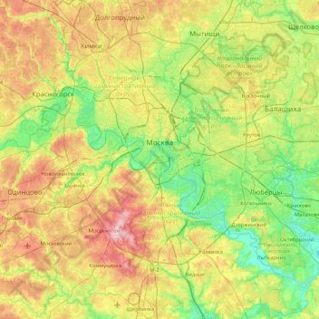
Nom : Carte topographique Moscow, altitude, relief.
Lieu : Moscow, Central Federal District, Russia (55.49131 37.29050 55.95777 37.96743)
Altitude moyenne : 161 m
Altitude minimum : 107 m
Altitude maximum : 257 m
Moscow is situated on the banks of the Moskva River, which flows for just over 500 km (311 mi) through the East European Plain in central Russia, not far from the natural border of the forest and forest-steppe zone. 49 bridges span the river and its canals within the city's limits. The elevation of Moscow at the All-Russia Exhibition Center (VVC), where the leading Moscow weather station is situated, is 156 metres (512 feet). Teplostan Upland is the city's highest point at 255 metres (837 feet). The width of Moscow city (not limiting MKAD) from west to east is 39.7 km (24.7 mi), and the length from north to south is 51.8 km (32.2 mi).
Autres cartes topographiques
Cliquez sur une carte pour visualiser sa topographie, son altitude et son relief.
Римский дворик
Римский дворик, 38, Arbat District, Moscow, Central Federal District, 121019, Russia
Altitude moyenne : 145 m
Prospekt Vernadskogo District
Russia > Moscow > Prospekt Vernadskogo District
Prospekt Vernadskogo District, Western Administrative Okrug, Moscow, Central Federal District, Russia
Altitude moyenne : 185 m