
Carte topographique Lemon Creek
Carte interactive
Cliquez sur la carte pour afficher l’altitude.
À propos de cette carte
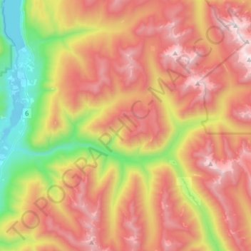
Nom : Carte topographique Lemon Creek, altitude, relief.
Altitude moyenne : 1 527 m
Altitude minimum : 531 m
Altitude maximum : 2 472 m
Autres cartes topographiques
Cliquez sur une carte pour visualiser sa topographie, son altitude et son relief.
Playmor Junction
Canada > British Columbia > Regional District of Central Kootenay > Area H (The Slocan Valley) > South Slocan
Playmor Junction, South Slocan, Area H (The Slocan Valley), Regional District of Central Kootenay, British Columbia, V0G 2G0, Canada
Altitude moyenne : 578 m
Winlaw
Canada > British Columbia > Regional District of Central Kootenay > Area H (The Slocan Valley)
Winlaw, Area H (The Slocan Valley), Regional District of Central Kootenay, British Columbia, V0G 2J0, Canada
Altitude moyenne : 694 m