
Faire un don
Équipez-vous pour votre prochaine aventure :
En tant que Partenaire Amazon, ce site perçoit une commission sur les achats éligibles sans surcoût pour vous.
Carte topographique 3
Cliquez sur la carte pour afficher l’altitude.
Faire un don
Équipez-vous pour votre prochaine aventure :
En tant que Partenaire Amazon, ce site perçoit une commission sur les achats éligibles sans surcoût pour vous.
À propos de cette carte
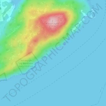
Nom : Carte topographique 3, altitude, relief.
Lieu : 3, Senja, Troms, Norway (69.17199 17.96795 69.19199 17.98795)
Altitude moyenne : 36 m
Altitude minimum : -24 m
Altitude maximum : 204 m
Faire un don
Équipez-vous pour votre prochaine aventure :
En tant que Partenaire Amazon, ce site perçoit une commission sur les achats éligibles sans surcoût pour vous.
Autres cartes topographiques
Cliquez sur une carte pour visualiser sa topographie, son altitude et son relief.
Tromsø
Outside the city, large areas in the municipality are at some altitude and above the treeline with an alpine tundra climate (ET). The islands to the west at the outer seabord are milder in winter like Måsvik, making this part of the municipality a subpolar oceanic climate (Cfc) zone. The average date for…
Altitude moyenne : 193 m
Tromsø
Outside the city, large areas in the municipality are at some altitude and above the treeline with an alpine tundra climate (ET or ETh). The islands to the west at the outer seaboard are milder in winter like Måsvik, making this part of the municipality a (if the −3.0 °C (26.6 °F) isotherm is used)…
Altitude moyenne : 193 m
Faire un don
Équipez-vous pour votre prochaine aventure :
En tant que Partenaire Amazon, ce site perçoit une commission sur les achats éligibles sans surcoût pour vous.
Tromsø
Recent years have seen warming. The recent normal period 1991–2020 shows that the part of the city at low altitude has winters so mild that melting of snow is more likely also in mid-winter; Tromsø-Holt (20 m) coldest month (February) mean is −2.4 °C (27.7 °F); subpolar oceanic if the −3.0 °C (26.6…
Altitude moyenne : 193 m
Faire un don
Équipez-vous pour votre prochaine aventure :
En tant que Partenaire Amazon, ce site perçoit une commission sur les achats éligibles sans surcoût pour vous.
Tromsø
Outside the city, large areas in the municipality are at some altitude and above the treeline with an alpine tundra climate (ET or ETh). The islands to the west at the outer seaboard are milder in winter like Måsvik, making this part of the municipality a (if the −3.0 °C (26.6 °F) isotherm is used)…
Altitude moyenne : 193 m
Faire un don
Équipez-vous pour votre prochaine aventure :
En tant que Partenaire Amazon, ce site perçoit une commission sur les achats éligibles sans surcoût pour vous.