
Carte topographique Dane County
Carte interactive
Cliquez sur la carte pour afficher l’altitude.
À propos de cette carte
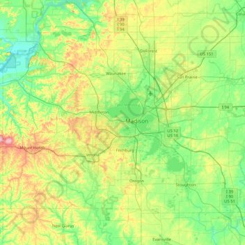
Nom : Carte topographique Dane County, altitude, relief.
Lieu : Dane County, Wisconsin, USA (42.84515 -89.83857 43.29416 -89.00883)
Altitude moyenne : 289 m
Altitude minimum : 218 m
Altitude maximum : 477 m
Autres cartes topographiques
Cliquez sur une carte pour visualiser sa topographie, son altitude et son relief.
Burnham Park
Burnham Park, Milwaukee, Milwaukee County, Wisconsin, USA
Altitude moyenne : 201 m
James Madison Park
James Madison Park, Madison, Dane County, Wisconsin, USA
Altitude moyenne : 263 m
Anchor Island
Anchor Island, Town of Oma, Iron County, Wisconsin, USA
Altitude moyenne : 462 m
Adams Beach
USA > Wisconsin > Adams Beach
Adams Beach, Town of Belle Plaine, Shawano County, Wisconsin, 54933, USA
Altitude moyenne : 249 m