
Carte topographique Erie County
Carte interactive
Cliquez sur la carte pour afficher l’altitude.
À propos de cette carte
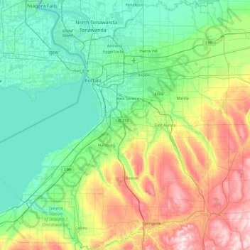
Nom : Carte topographique Erie County, altitude, relief.
Lieu : Erie County, New York, VS (42.43812 -79.13962 43.09870 -78.46281)
Altitude moyenne : 286 m
Altitude minimum : 156 m
Altitude maximum : 649 m
Autres cartes topographiques
Cliquez sur une carte pour visualiser sa topographie, son altitude et son relief.
Bronxville
VS > New York > Bronxville > Town of Eastchester
Bronxville, Town of Eastchester, Westchester County, New York, 10708, VS
Altitude moyenne : 48 m
Ellicottville
VS > New York > Ellicottville
Ellicottville, Cattaraugus County, New York, 14731, VS
Altitude moyenne : 523 m
Head of the Harbor
VS > New York > Head of the Harbor
Head of the Harbor, Suffolk County, New York, VS
Altitude moyenne : 35 m
Schenectady
VS > New York > Schenectady
Schenectady, Schenectady County, New York, VS
Altitude moyenne : 100 m
Bramanville
VS > New York > Bramanville
Bramanville, Town of Cobleskill, Schoharie County, New York, 12092, VS
Altitude moyenne : 320 m
Kings Park
VS > New York > Kings Park
Kings Park, Suffolk County, New York, 11754, VS
Altitude moyenne : 37 m
Staten Island
Staten Island, Richmond County, NYC, New York, VS
Altitude moyenne : 11 m
Port Washington
VS > New York > Port Washington
Port Washington, Nassau County, New York, VS
Altitude moyenne : 22 m