
Faire un don
Équipez-vous pour votre prochaine aventure :
En tant que Partenaire Amazon, ce site perçoit une commission sur les achats éligibles sans surcoût pour vous.
Carte topographique Oldupai Gorge
Cliquez sur la carte pour afficher l’altitude.
Faire un don
Équipez-vous pour votre prochaine aventure :
En tant que Partenaire Amazon, ce site perçoit une commission sur les achats éligibles sans surcoût pour vous.
À propos de cette carte
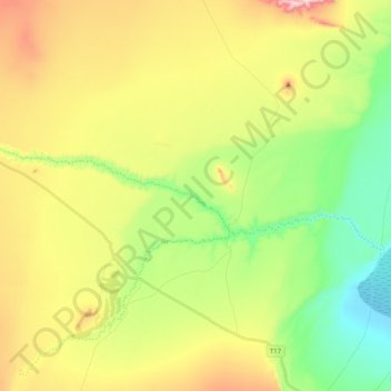
Nom : Carte topographique Oldupai Gorge, altitude, relief.
Lieu : Oldupai Gorge, Ngorongoro, Arusha, Northern Zone, Tanzania (-3.00000 35.22810 -2.94379 35.42896)
Altitude moyenne : 1 494 m
Altitude minimum : 1 300 m
Altitude maximum : 1 782 m
Faire un don
Équipez-vous pour votre prochaine aventure :
En tant que Partenaire Amazon, ce site perçoit une commission sur les achats éligibles sans surcoût pour vous.
Autres cartes topographiques
Cliquez sur une carte pour visualiser sa topographie, son altitude et son relief.
Monduli
A number of isolated mountains (Monduli, Lepurko, Loosimingori, and Lengai) and broad rolling plains characterize the land landscape. The heights range from 600m in the low elevations to 2900m in the high elevations. The District's vegetation includes a combination of forest, bushland, woodland grassland, and…
Altitude moyenne : 1 369 m
Karatu
Karatu District (Wilaya ya Karatu, in Swahili) is one of seven districts of the Arusha Region of Tanzania. The district is bordered to the north by the Ngorongoro District and to the west by the Meatu District in the Simiyu Region. The district is bordered to the east by the Monduli District, and to the south…
Altitude moyenne : 1 468 m
Faire un don
Équipez-vous pour votre prochaine aventure :
En tant que Partenaire Amazon, ce site perçoit une commission sur les achats éligibles sans surcoût pour vous.
Faire un don
Équipez-vous pour votre prochaine aventure :
En tant que Partenaire Amazon, ce site perçoit une commission sur les achats éligibles sans surcoût pour vous.
Monduli
A number of isolated mountains (Monduli, Lepurko, Loosimingori, and Lengai) and broad rolling plains characterize the land landscape. The heights range from 600m in the low elevations to 2900m in the high elevations. The District's vegetation includes a combination of forest, bushland, woodland grassland, and…
Altitude moyenne : 1 369 m
Arusha
Despite its proximity to the equator, Arusha's elevation of 1,400 metres (4,600 ft) on the southern slopes of Mount Meru keeps temperatures relatively low and alleviates humidity. Cool dry air is prevalent for much of the year. The temperature typically ranges between 10 and 30 °C (50 and 86 °F) with an…
Altitude moyenne : 1 572 m
Faire un don
Équipez-vous pour votre prochaine aventure :
En tant que Partenaire Amazon, ce site perçoit une commission sur les achats éligibles sans surcoût pour vous.
Arusha
Despite its proximity to the equator, Arusha's elevation of 1,400 metres (4,600 ft) on the southern slopes of Mount Meru keeps temperatures relatively low and alleviates humidity. Cool dry air is prevalent for much of the year. The temperature typically ranges between 10 and 30 °C (50 and 86 °F) with an…
Altitude moyenne : 1 572 m
Faire un don
Équipez-vous pour votre prochaine aventure :
En tant que Partenaire Amazon, ce site perçoit une commission sur les achats éligibles sans surcoût pour vous.
Faire un don
Équipez-vous pour votre prochaine aventure :
En tant que Partenaire Amazon, ce site perçoit une commission sur les achats éligibles sans surcoût pour vous.