
Carte topographique Twentynine Palms
Carte interactive
Cliquez sur la carte pour afficher l’altitude.
À propos de cette carte
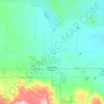
Nom : Carte topographique Twentynine Palms, altitude, relief.
Altitude moyenne : 690 m
Altitude minimum : 489 m
Altitude maximum : 1 546 m
According to the United States Census Bureau, the city has a total area of 59.1 square miles (153 km2), all land. The city is at an elevation of 1,988 feet (606 m). The Marine Corps Air Ground Combat Center Twentynine Palms is located there.
Autres cartes topographiques
Cliquez sur une carte pour visualiser sa topographie, son altitude et son relief.
Twenty-Nine Palms Band
United States > California > San Bernardino County > Twentynine Palms
Twenty-Nine Palms Band, Twentynine Palms, San Bernardino County, California, United States
Altitude moyenne : 899 m