
Carte topographique Yongfu County
Carte interactive
Cliquez sur la carte pour afficher l’altitude.
À propos de cette carte
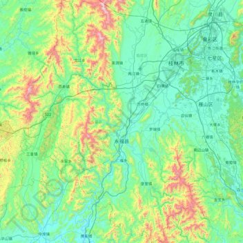
Nom : Carte topographique Yongfu County, altitude, relief.
Lieu : Yongfu County, Guilin, Guangxi, China (24.64826 109.61164 25.44246 110.23691)
Altitude moyenne : 344 m
Altitude minimum : 101 m
Altitude maximum : 1 361 m
Yongfu County (Chinese: 永福县; pinyin: Yǒngfú Xiàn) is a county under the administration of the prefecture-level city of Guilin, Guangxi, China, located 55 km (34 mi) to the southwest of downtown Guilin. The county is mostly rural and hilly, marked by the same dramatic karst topography for which Guilin is famous.