
Carte topographique Burgos
Carte interactive
Cliquez sur la carte pour afficher l’altitude.
À propos de cette carte
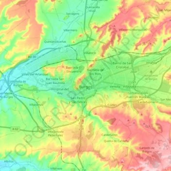
Nom : Carte topographique Burgos, altitude, relief.
Lieu : Burgos, Castile and León, Spain (42.28528 -3.79437 42.40428 -3.58534)
Altitude moyenne : 907 m
Altitude minimum : 820 m
Altitude maximum : 1 031 m
At an elevation of 865 metres (2,838 ft), the city of Burgos lies in the transition zone between a Warm-summer Mediterranean climate (Köppen Csb) and an Oceanic climate (Köppen Cfb), with some continental influence resulting from its distance from the sea and higher altitude. Burgos' climate features chilly and windy winters, due to altitude and an inland location, which always include snow and temperatures below freezing. Temperature ranges can be extreme and Burgos is drier than Spain's coastal regions, although there is year-round precipitation. Average annual precipitation is 546 mm (21.5 in) and the average annual relative humidity is 72%. In winter, temperatures very often (almost every day) drop below freezing, often reaching temperatures as low as −10 °C (14 °F), and snowfalls are common, while the summer months see average high temperatures of 27.5 °C (81.5 °F). The lowest recorded temperature in Burgos was −21 °C (−6 °F) on 20 January 1885. The highest recorded temperature was 39 °C (102 °F) on 13 August 1987.