
Carte topographique North Bay
Carte interactive
Cliquez sur la carte pour afficher l’altitude.
À propos de cette carte
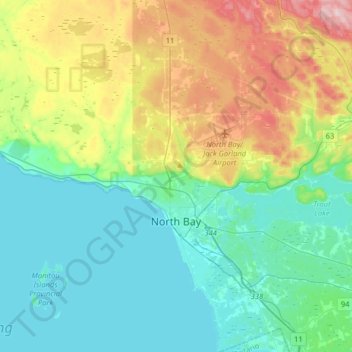
Nom : Carte topographique North Bay, altitude, relief.
Altitude moyenne : 266 m
Altitude minimum : 190 m
Altitude maximum : 472 m
The climate in North Bay is common to most places in Northern Ontario. North Bay tends to be a less humid climate than that found in Southern Ontario due somewhat to the distance from the Great Lakes and less warm than some other locations in Northern Ontario due to cooling from Lake Nipissing. On May 31, 2002, a tornado caused minor damage near the city. Two more tornadoes touched down on Lake Nipissing on August 20, 2009. This storm was a part of a chain of tornadoes that caused large amounts of damage in other parts of Ontario. The weather box below shows climate normals for the airport, at an elevation of 358 m, but the majority of the city, including the downtown core, sits at an elevation of 201 m.
Autres cartes topographiques
Cliquez sur une carte pour visualiser sa topographie, son altitude et son relief.
Field
Canada > Ontario > Nipissing District > Field
Field, West Nipissing, Nipissing District, Northeastern Ontario, Ontario, Canada
Altitude moyenne : 248 m