
Faire un don
Équipez-vous pour votre prochaine aventure :
En tant que Partenaire Amazon, ce site perçoit une commission sur les achats éligibles sans surcoût pour vous.
Carte topographique Wiernsheim
Cliquez sur la carte pour afficher l’altitude.
Faire un don
Équipez-vous pour votre prochaine aventure :
En tant que Partenaire Amazon, ce site perçoit une commission sur les achats éligibles sans surcoût pour vous.
Wiernsheim
The municipality (Gemeinde) of Wiernsheim covers 24.62 kilometers (15.30 mi) of the Enzkreis, a district of the state of Baden-Württemberg and the Federal Republic of Germany. It is located in the metropolitan areas of Karlsruhe and Pforzheim, along the southwestern edge of the Neckar basin [de]. Wiernsheim is physically in the Heckengäu, a region characterized by wooded and karstified hills of muschelkalk. Elevation above sea level in municipal area ranges from a low of 274 meters (899 ft) Normalnull (NN) on the Kreuzbach and a high of 464 meters (1,522 ft) NN in the southwest.
Faire un don
Équipez-vous pour votre prochaine aventure :
En tant que Partenaire Amazon, ce site perçoit une commission sur les achats éligibles sans surcoût pour vous.
À propos de cette carte
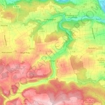
Nom : Carte topographique Wiernsheim, altitude, relief.
Altitude moyenne : 358 m
Altitude minimum : 202 m
Altitude maximum : 482 m
Faire un don
Équipez-vous pour votre prochaine aventure :
En tant que Partenaire Amazon, ce site perçoit une commission sur les achats éligibles sans surcoût pour vous.
Autres cartes topographiques
Cliquez sur une carte pour visualiser sa topographie, son altitude et son relief.
Holzbachtal
Germany > Baden-Württemberg > Enzkreis > Straubenhardt > Langenalb
Altitude moyenne : 449 m
Faire un don
Équipez-vous pour votre prochaine aventure :
En tant que Partenaire Amazon, ce site perçoit une commission sur les achats éligibles sans surcoût pour vous.