
Carte topographique Santa Barbara
Carte interactive
Cliquez sur la carte pour afficher l’altitude.
À propos de cette carte
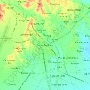
Nom : Carte topographique Santa Barbara, altitude, relief.
Lieu : Santa Barbara, Iloilo, Western Visayas, 5002, Philippines (10.78723 122.49147 10.86723 122.57147)
Altitude moyenne : 34 m
Altitude minimum : 10 m
Altitude maximum : 79 m
The topography of Santa Barbara varies from slightly rolling hills to almost flat or gradually inclined plains, sliced by Tigum River at its centremost, which flows from the north-west to the southeast and the Aganan River in the southern section.