
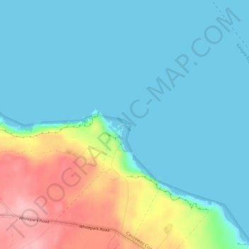
Carte topographique Kinbane Head
Carte interactive
Cliquez sur la carte pour afficher l’altitude.
À propos de cette carte
Nom : Carte topographique Kinbane Head, altitude, relief.
Altitude moyenne : 35 m
Altitude minimum : -1 m
Altitude maximum : 144 m
Autres cartes topographiques
Cliquez sur une carte pour visualiser sa topographie, son altitude et son relief.
Antrim
United Kingdom > Northern Ireland > County Antrim
Antrim, County Antrim, Northern Ireland, BT41 4AR, United Kingdom
Altitude moyenne : 50 m
Drains Bay
United Kingdom > Northern Ireland > County Antrim
Drains Bay, County Antrim, Northern Ireland, BT40 2LG, United Kingdom
Altitude moyenne : 38 m
Carnlough
United Kingdom > Northern Ireland > County Antrim
Carnlough, County Antrim, Northern Ireland, BT44 0EU, United Kingdom
Altitude moyenne : 77 m
Portrush
United Kingdom > Northern Ireland > County Antrim
Portrush, County Antrim, Northern Ireland, BT56 8BN, United Kingdom
Altitude moyenne : 23 m
Newtownabbey
United Kingdom > Northern Ireland > County Antrim
Newtownabbey, County Antrim, Northern Ireland, BT36 6UN, United Kingdom
Altitude moyenne : 100 m
Dunseverick Castle
United Kingdom > Northern Ireland > County Antrim > Dunseverick
Dunseverick Castle, Causeway Coastal Way, Dunseverick, County Antrim, Ulster, Northern Ireland, BT57 8SR, United Kingdom
Altitude moyenne : 29 m
Belfast
United Kingdom > Northern Ireland > County Antrim
Belfast, County Antrim, Ulster, Northern Ireland, BT1 5GS, United Kingdom
Altitude moyenne : 87 m
Rathkenny
United Kingdom > Northern Ireland > County Antrim
Rathkenny, County Antrim, Ulster, Northern Ireland, United Kingdom
Altitude moyenne : 147 m
Martinstown
United Kingdom > Northern Ireland > County Antrim > Martinstown
Martinstown, County Antrim, Northern Ireland, BT43 6QH, United Kingdom
Altitude moyenne : 174 m
Liscolman
United Kingdom > Northern Ireland > County Antrim > Liscolman
Liscolman, County Antrim, Northern Ireland, BT53 8EE, United Kingdom
Altitude moyenne : 71 m
Red Bay Castle
United Kingdom > Northern Ireland > County Antrim > Waterfoot
Red Bay Castle, Coast Road A2, Waterfoot, County Antrim, Northern Ireland, BT44 0SQ, United Kingdom
Altitude moyenne : 31 m
Woodburn
United Kingdom > Northern Ireland > County Antrim > Carrickfergus
Woodburn, Carrickfergus, County Antrim, Northern Ireland, BT38 8QB, United Kingdom
Altitude moyenne : 87 m
Ballyvoy
United Kingdom > Northern Ireland > County Antrim > Ballyvoy
Ballyvoy, County Antrim, Northern Ireland, BT54 6QY, United Kingdom
Altitude moyenne : 74 m
Torr Head
United Kingdom > Northern Ireland > County Antrim
Torr Head, County Antrim, Northern Ireland, United Kingdom
Altitude moyenne : 44 m
Ballycoos
United Kingdom > Northern Ireland > County Antrim
Ballycoos, County Antrim, Northern Ireland, BT40 2RR, United Kingdom
Altitude moyenne : 259 m
Glenarm
United Kingdom > Northern Ireland > County Antrim > Glenarm
Glenarm, County Antrim, Northern Ireland, BT44 0AA, United Kingdom
Altitude moyenne : 67 m
Fair Head
United Kingdom > Northern Ireland > County Antrim
Fair Head, Fairhead Road, County Antrim, Northern Ireland, BT54 6RL, United Kingdom
Altitude moyenne : 55 m
Ballintoy
United Kingdom > Northern Ireland > County Antrim > Ballintoy
Ballintoy, County Antrim, Northern Ireland, BT54 6LX, United Kingdom
Altitude moyenne : 73 m
Cross Slieve
United Kingdom > Northern Ireland > County Antrim
Cross Slieve, County Antrim, Northern Ireland, BT44 0NH, United Kingdom
Altitude moyenne : 97 m
Old Mill
United Kingdom > Northern Ireland > County Antrim > Ballygally > Old Mill
Old Mill, Ballygally, County Antrim, Northern Ireland, BT40 2RX, United Kingdom
Altitude moyenne : 47 m
Rathlin Island
United Kingdom > Northern Ireland > County Antrim > Church Bay
Rathlin Island, Church Bay, County Antrim, Northern Ireland, United Kingdom
Altitude moyenne : 10 m
Carncormick
United Kingdom > Northern Ireland > County Antrim
Carncormick, County Antrim, Northern Ireland, BT43 7NA, United Kingdom
Altitude moyenne : 314 m
Armoy
United Kingdom > Northern Ireland > County Antrim > Armoy
Armoy, County Antrim, Northern Ireland, BT53 8RH, United Kingdom
Altitude moyenne : 102 m
Antrim Round Tower
United Kingdom > Northern Ireland > County Antrim > Antrim
Antrim Round Tower, Steeple Road, Antrim, County Antrim, Northern Ireland, BT41 1BB, United Kingdom
Altitude moyenne : 45 m
Crockalough
United Kingdom > Northern Ireland > County Antrim
Crockalough, County Antrim, Northern Ireland, BT44 0QZ, United Kingdom
Altitude moyenne : 306 m
Ballycastle
United Kingdom > Northern Ireland > County Antrim
Ballycastle, County Antrim, Northern Ireland, BT54 6AW, United Kingdom
Altitude moyenne : 79 m
Knocklayd
United Kingdom > Northern Ireland > County Antrim
Knocklayd, County Antrim, Northern Ireland, BT54 6PF, United Kingdom
Altitude moyenne : 309 m