
Carte topographique Golden Bay
Carte interactive
Cliquez sur la carte pour afficher l’altitude.
À propos de cette carte
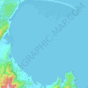
Nom : Carte topographique Golden Bay, altitude, relief.
Lieu : Golden Bay, Tasman, 7073, New Zealand (-40.84577 172.64619 -40.51333 173.03853)
Altitude moyenne : 43 m
Altitude minimum : -2 m
Altitude maximum : 1 259 m
Autres cartes topographiques
Cliquez sur une carte pour visualiser sa topographie, son altitude et son relief.
Kaituna River
New Zealand > Tasman > Tasman District
Kaituna River, Tasman District, Tasman, New Zealand
Altitude moyenne : 263 m
Clifton
New Zealand > Tasman > Pohara > Clifton
Clifton, Pohara, Tasman, 7183, New Zealand
Altitude moyenne : 68 m
Ngatimoti
New Zealand > Tasman > Ngatimoti
Ngatimoti, Tasman, 7196, New Zealand
Altitude moyenne : 103 m
Abel Tasman National Park
Abel Tasman National Park, Tasman, New Zealand
Altitude moyenne : 271 m
Wakefield
New Zealand > Tasman > Wakefield
Wakefield, Tasman, 7025, New Zealand
Altitude moyenne : 134 m