
Carte topographique Buk-gu
Carte interactive
Cliquez sur la carte pour afficher l’altitude.
À propos de cette carte
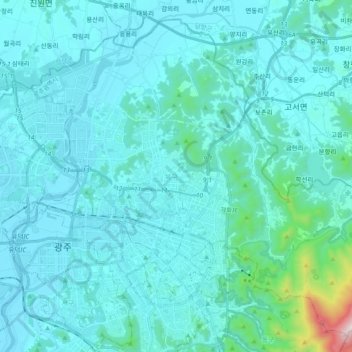
Nom : Carte topographique Buk-gu, altitude, relief.
Lieu : Buk-gu, Gwangju, South Korea (35.12109 126.83489 35.25880 127.02330)
Altitude moyenne : 101 m
Altitude minimum : 7 m
Altitude maximum : 1 142 m
Autres cartes topographiques
Cliquez sur une carte pour visualiser sa topographie, son altitude et son relief.