
Carte topographique Hobart
Carte interactive
Cliquez sur la carte pour afficher l’altitude.
À propos de cette carte
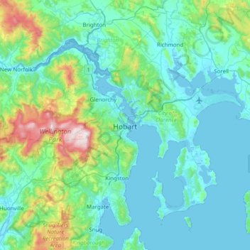
Nom : Carte topographique Hobart, altitude, relief.
Lieu : Hobart, City of Hobart, Tasmania, Australia (-43.10362 147.09169 -42.65538 147.64559)
Altitude moyenne : 179 m
Altitude minimum : -2 m
Altitude maximum : 1 260 m
Although Hobart itself rarely receives snow during the winter due to the foehn effect created by the Central Highlands (the city's geographic position causes a rain shadow), the adjacent Kunanyi/Mount Wellington is frequently seen with a snowcap throughout the year including in summer. During the 20th century, the city itself has received snowfalls at sea level on average only once every 5 years; however, outer suburbs lying higher on the slopes of Mount Wellington receive snow more often, owing to the more exposed position coupled with them resting at higher altitude. These snow-bearing winds often carry on through Tasmania and Victoria to the Snowy Mountains in Victoria and southern New South Wales.
Autres cartes topographiques
Cliquez sur une carte pour visualiser sa topographie, son altitude et son relief.
Launceston
Launceston, City of Launceston, Tasmania, Australia
Altitude moyenne : 194 m
Queenstown
Queenstown, West Coast, Tasmania, 7467, Australia
Altitude moyenne : 330 m
Campbell Town
Australia > Tasmania > Campbell Town
Campbell Town, Northern Midlands, Tasmania, 7210, Australia
Altitude moyenne : 345 m
Clarence Point
Australia > Tasmania > Clarence Point
Clarence Point, West Tamar, Tasmania, Australia
Altitude moyenne : 13 m
Legana
Australia > Tasmania > Launceston > Legana
Legana, Launceston, West Tamar, Tasmania, Australia
Altitude moyenne : 82 m
Mount Nelson
Mount Nelson, Hobart, City of Hobart, Tasmania, Australia
Altitude moyenne : 198 m