Géolocaliser

Carte topographique Pampady

Cliquez sur la carte pour afficher l’altitude.

À propos de cette carte

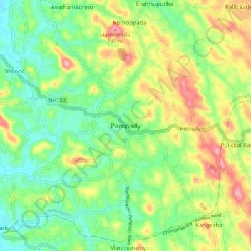
Nom : Carte topographique Pampady, altitude, relief.

Lieu : Pampady, Kottayam, Kerala, 686502, India (9.52563 76.60436 9.60563 76.68436)

Altitude moyenne : 55 m

Altitude minimum : 4 m

Altitude maximum : 135 m

Autres cartes topographiques

Cliquez sur une carte pour visualiser sa topographie, son altitude et son relief.

Sankranthi

India > Kerala > Kottayam > Kottayam

Altitude moyenne : 15 m

Meenadom

India > Kerala > Kottayam > Pariyaram

Altitude moyenne : 36 m

Manimala River

India > Kerala > Kottayam > Eravinalloor

Altitude moyenne : 12 m

Kanjikuzhy

India > Kerala > Kottayam > Manganam

Altitude moyenne : 14 m

Meenachil

India > Kerala > Kottayam > Pulikuttisseri

Altitude moyenne : 7 m

Karapuzha

India > Kerala > Kottayam > Kottayam

Altitude moyenne : 7 m

Alapuzha

India > Kerala > Kottayam > Kottayam

Altitude moyenne : 10 m

child

India > Kerala > Kottayam > Thiruvanchoor

Altitude moyenne : 13 m

Alapuzha

India > Kerala > Kottayam > Kottayam

Altitude moyenne : 10 m

Alapuzha

India > Kerala > Kottayam > Kottayam

Altitude moyenne : 10 m

Équipez-vous pour votre prochaine aventure :

🥤Poches à eau - Systèmes d'hydratation pour sac à dos
🚲Support smartphone pour vélo - Utilisez topographic-map.com en direct sur votre guidon
📱Étui de téléphone étanche - Protégez votre smartphone des chutes dans l'eau ou de la boue
🧭Boussoles de navigation - Boussoles fiables pour orientation et cartographie
🧳Sacs étanches - Protection du matériel contre l'eau

En tant que Partenaire Amazon, ce site perçoit une commission sur les achats éligibles sans surcoût pour vous.