
Carte topographique Province of Oxapampa
Carte interactive
Cliquez sur la carte pour afficher l’altitude.
À propos de cette carte
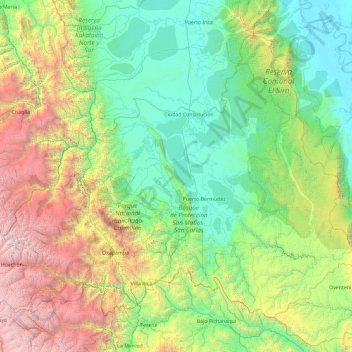
Nom : Carte topographique Province of Oxapampa, altitude, relief.
Lieu : Province of Oxapampa, Pasco, 19230, Peru (-10.91260 -75.98550 -9.44570 -74.13203)
Altitude moyenne : 1 348 m
Altitude minimum : 152 m
Altitude maximum : 5 332 m
The Oxapampa Province (Spanish: Provincia de Oxapampa) is the largest of three provinces that make up the Pasco Region in Peru. The capital of the Oxapampa province is the city of Oxapampa. The province is located on the eastern slopes of the Andes reaching down to the lowlands of the Amazon Basin. The high point of the province is approximately 5,300 metres (17,400 ft) in elevation near the summit of Huaguruncho mountain in the Huancabamba District and the low point is approximately 200 metres (660 ft) on the Pachitea River in the Constitución District.
Autres cartes topographiques
Cliquez sur une carte pour visualiser sa topographie, son altitude et son relief.
Orellana
Peru > Pasco > Constitución
Orellana, Constitución, Province of Oxapampa, Pasco, Peru
Altitude moyenne : 241 m
Cerro de Pasco
Cerro de Pasco, Chaupimarca, Province of Pasco, Pasco, Peru
Altitude moyenne : 4 239 m
Villo
Peru > Pasco > Yanahuanca
Villo, Yanahuanca, Province of Daniel Carrión, Pasco, Peru
Altitude moyenne : 3 764 m