
Carte topographique Marston
Carte interactive
Cliquez sur la carte pour afficher l’altitude.
À propos de cette carte
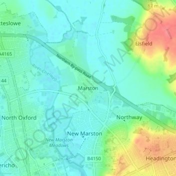
Nom : Carte topographique Marston, altitude, relief.
Lieu : Marston, Oxford, Oxfordshire, England, OX3 0PX, United Kingdom (51.75615 -1.25791 51.79615 -1.21791)
Altitude moyenne : 71 m
Altitude minimum : 54 m
Altitude maximum : 122 m
Autres cartes topographiques
Cliquez sur une carte pour visualiser sa topographie, son altitude et son relief.
Botley Stream
United Kingdom > England > Oxfordshire > Oxford
Botley Stream, New Botley, West Oxford, Oxford, Oxfordshire, England, OX2 0ED, United Kingdom
Altitude moyenne : 67 m
Binsey
United Kingdom > England > Oxfordshire > Oxford
Binsey, Oxford, Oxfordshire, England, OX2 0NG, United Kingdom
Altitude moyenne : 64 m
Oxford
United Kingdom > England > Oxfordshire > Oxford
Oxford, Oxfordshire, South East England, England, OX1 3HY, United Kingdom
Altitude moyenne : 81 m
The Triangle
United Kingdom > England > Oxfordshire > Oxford
The Triangle, Iffley, Oxford, Oxfordshire, South East England, England, United Kingdom
Altitude moyenne : 63 m
Littlemore
United Kingdom > England > Oxfordshire > Oxford
Littlemore, Oxford, Oxfordshire, England, United Kingdom
Altitude moyenne : 67 m