
Carte topographique Cumming
Carte interactive
Cliquez sur la carte pour afficher l’altitude.
À propos de cette carte
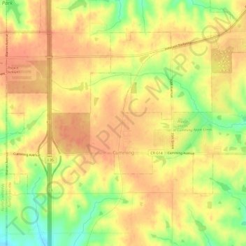
Nom : Carte topographique Cumming, altitude, relief.
Lieu : Cumming, Warren County, Iowa, United States (41.47587 -93.79063 41.50136 -93.73133)
Altitude moyenne : 290 m
Altitude minimum : 258 m
Altitude maximum : 306 m
Autres cartes topographiques
Cliquez sur une carte pour visualiser sa topographie, son altitude et son relief.
New Virginia
United States > Iowa > Warren County
New Virginia, Warren County, Iowa, United States
Altitude moyenne : 318 m
Lacona
United States > Iowa > Warren County
Lacona, Warren County, Iowa, United States
Altitude moyenne : 265 m
Milo
United States > Iowa > Warren County
Milo, Warren County, Iowa, United States
Altitude moyenne : 292 m
Norwalk
United States > Iowa > Warren County
Norwalk, Warren County, Iowa, 50211, United States
Altitude moyenne : 271 m
Spring Hill
United States > Iowa > Warren County
Spring Hill, Warren County, Iowa, United States
Altitude moyenne : 263 m
Ackworth
United States > Iowa > Warren County > Ackworth
Ackworth, Warren County, Iowa, United States
Altitude moyenne : 261 m
Indianola
United States > Iowa > Warren County
Indianola, Warren County, Iowa, 50125, United States
Altitude moyenne : 278 m
Spring Hill
United States > Iowa > Warren County > Spring Hill
Spring Hill, Warren County, Iowa, United States
Altitude moyenne : 265 m