
Carte topographique Vișeu de Sus
Carte interactive
Cliquez sur la carte pour afficher l’altitude.
À propos de cette carte
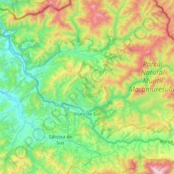
Nom : Carte topographique Vișeu de Sus, altitude, relief.
Lieu : Vișeu de Sus, Maramureș, Romania (47.65891 24.37557 47.86529 24.88777)
Altitude moyenne : 865 m
Altitude minimum : 348 m
Altitude maximum : 2 266 m
Vișeu de Sus is located in the northeastern part of Maramureș County, on the border with Ukraine. The town lies at the confluence of the rivers Vișeu and Vaser, at an altitude of 427 m (1,401 ft) above sea level, having the characteristics of a mountain city. It neighbors the communes of Moisei to the southeast, Vișeu de Jos to the west, and Poienile de sub Munte to the northwest. It also borders Maramureș Mountains Natural Park to the north, and Rodna Mountains National Park to the south-east. The town administers a surface area of 44,306 ha (109,480 acres), making it the second-largest town by area in Romania.
Autres cartes topographiques
Cliquez sur une carte pour visualiser sa topographie, son altitude et son relief.
Săliștea de Sus
Săliștea de Sus, Maramureș, 437295, Romania
Altitude moyenne : 716 m
Pârcălabul
Pârcălabul, Borșa, Maramureș, Romania
Altitude moyenne : 1 343 m
Băile Borșa
Băile Borșa, Borșa, Maramureș, 435250, Romania
Altitude moyenne : 917 m
Jugăstreni
Jugăstreni, Vima Mică, Maramureș, 437383, Romania
Altitude moyenne : 375 m
Chiuzbaia
Romania > Maramureș > Baia Sprie > Chiuzbaia
Chiuzbaia, Baia Sprie, Maramureș, 435101, Romania
Altitude moyenne : 635 m
Sighetu Marmatiei
Romania > Maramureș > Sighetu Marmatiei
Sighetu Marmatiei, Sighetu Marmației, Maramureș, 435500, Romania
Altitude moyenne : 312 m