
Carte topographique Chakrata
Cliquez sur la carte pour afficher l’altitude.
Chakrata
It lies between the Tons and Yamuna rivers, at an elevation of 2118 m, 98 km from the state capital, Dehradun. Chakrata was originally a cantonment of the British Indian Army. To the west lies Shillai, Himachal Pradesh, and to the east are Mussoorie (73 km) and Tehri Garhwal.
À propos de cette carte
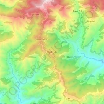
Nom : Carte topographique Chakrata, altitude, relief.
Lieu : Chakrata, Dehradun, Uttarakhand, 248123, India (30.66132 77.83034 30.74132 77.91034)
Altitude moyenne : 1 851 m
Altitude minimum : 1 220 m
Altitude maximum : 2 780 m