
Carte topographique Thrissur
Cliquez sur la carte pour afficher l’altitude.
Thrissur
Thrissur is the headquarters of Thrissur district, in the centre of the Indian state of Kerala. The city is 75 km north-east of Kochi, 133 km south-west of Coimbatore, 124 km south-east of Kozhikode and 151 km north of Changanacherry. The city is located in a hillock called Thekkinkadu Maidan which is the second highest point in city after the Vilangan Hills. The city has an average altitude of 2.83 metres above sea level.
À propos de cette carte
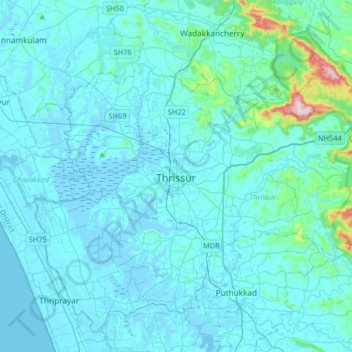
Nom : Carte topographique Thrissur, altitude, relief.
Lieu : Thrissur, Kerala, 680001, India (10.36701 76.05462 10.68701 76.37462)
Altitude moyenne : 36 m
Altitude minimum : -6 m
Altitude maximum : 516 m
Autres cartes topographiques
Cliquez sur une carte pour visualiser sa topographie, son altitude et son relief.
Kulam -Balakrishnan,Karamangattil, Chazhoor, Chetakulam
India > Kerala > Thrissur > Puthenpeedika
Altitude moyenne : 6 m