
Carte topographique Solferino
Carte interactive
Cliquez sur la carte pour afficher l’altitude.
À propos de cette carte
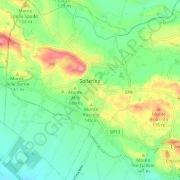
Nom : Carte topographique Solferino, altitude, relief.
Lieu : Solferino, Mantua, Lombardy, 46040, Italy (45.34248 10.53443 45.38982 10.58191)
Altitude moyenne : 119 m
Altitude minimum : 77 m
Altitude maximum : 198 m
The municipal territory, extending for 13.08 km2, is part of the Morainic amphitheatre of Lake Garda, located a few kilometres to the north. The altitude at the town hall is 124 m above sea level. Not far away also lies the province of Verona, with the towns of Peschiera del Garda and Valeggio sul Mincio, only a few kilometres to the east.
Autres cartes topographiques
Cliquez sur une carte pour visualiser sa topographie, son altitude et son relief.
Volta Mantovana
Italy > Lombardy > Mantua > Volta Mantovana
Volta Mantovana, Mantua, Lombardy, Italy
Altitude moyenne : 73 m
Castiglione delle Stiviere
Italy > Lombardy > Mantua > Castiglione delle Stiviere > Castiglione delle Stiviere
Castiglione delle Stiviere, Mantua, Lombardy, 46043, Italy
Altitude moyenne : 107 m
Sabbioneta
Italy > Lombardy > Mantua > Sabbioneta
Sabbioneta, Mantua, Lombardy, 46018, Italy
Altitude moyenne : 23 m