
Carte topographique Peermade
Cliquez sur la carte pour afficher l’altitude.
Peermade
The landscape of Peermade includes spectacular waterfalls, open grass lands and pine forests. Predominantly it is classified as Malanad with an elevation ranging from 3,000 ft (910 m) from the mean sea level.
À propos de cette carte
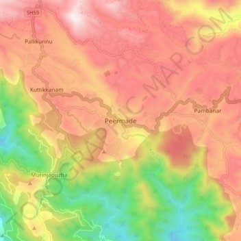
Nom : Carte topographique Peermade, altitude, relief.
Lieu : Peermade, Peerumade, Idukki, Kerala, 685531, India (9.53201 76.95590 9.61201 77.03590)
Altitude moyenne : 918 m
Altitude minimum : 300 m
Altitude maximum : 1 399 m
Autres cartes topographiques
Cliquez sur une carte pour visualiser sa topographie, son altitude et son relief.
Periyar National Park Tiger Reserve
Periyar National Park lies in the middle of a mountainous area of the Cardamom Hills. In the north : The boundary commences from the point nearest to the Medaganam in the interstate boundary up to Vellimalai. and the east Thence the boundary follows the inter-state boundary from Vellimalai to Kallimalai Peak…
Altitude moyenne : 929 m