
Faire un don
Équipez-vous pour votre prochaine aventure :
En tant que Partenaire Amazon, ce site perçoit une commission sur les achats éligibles sans surcoût pour vous.
Carte topographique San Juan
Cliquez sur la carte pour afficher l’altitude.
Faire un don
Équipez-vous pour votre prochaine aventure :
En tant que Partenaire Amazon, ce site perçoit une commission sur les achats éligibles sans surcoût pour vous.
San Juan
The topography of the town is characterized by hilly and mountainous terrain that gradually rises eastward from its coastal plains along the foothills of the Cordillera Central. The town is also traversed by several creeks and rivers, with the Baroro River being the most prominent.
Faire un don
Équipez-vous pour votre prochaine aventure :
En tant que Partenaire Amazon, ce site perçoit une commission sur les achats éligibles sans surcoût pour vous.
À propos de cette carte
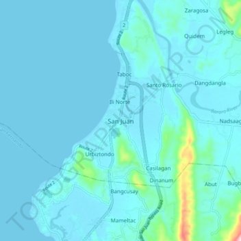
Nom : Carte topographique San Juan, altitude, relief.
Lieu : San Juan, La Union, Ilocos Region, 2515, Philippines (16.62993 120.29855 16.70993 120.37855)
Altitude moyenne : 21 m
Altitude minimum : -1 m
Altitude maximum : 283 m
Faire un don
Équipez-vous pour votre prochaine aventure :
En tant que Partenaire Amazon, ce site perçoit une commission sur les achats éligibles sans surcoût pour vous.
Autres cartes topographiques
Cliquez sur une carte pour visualiser sa topographie, son altitude et son relief.
Tubao
Rural topography is seventy percent (70%) alluvial plains and thirty percent (30%) uplands. Highest portion is located in Barangay Rizal, which is more than 500 metres (1,600 ft) above sea level along the foothill of Cordillera Central. Flat lands are found in the middle portion of the town, in between its…
Altitude moyenne : 84 m
Faire un don
Équipez-vous pour votre prochaine aventure :
En tant que Partenaire Amazon, ce site perçoit une commission sur les achats éligibles sans surcoût pour vous.
Rosario
The topography of Rosario is characterized by a valley with mountainous terrain, predominantly shaped by the sharply sloping mountains of the Cordillera Central range, which runs parallel to the coast of the South China Sea. To the west, the land features narrow plains and valleys, interspersed with shallow…
Altitude moyenne : 337 m
Faire un don
Équipez-vous pour votre prochaine aventure :
En tant que Partenaire Amazon, ce site perçoit une commission sur les achats éligibles sans surcoût pour vous.
Faire un don
Équipez-vous pour votre prochaine aventure :
En tant que Partenaire Amazon, ce site perçoit une commission sur les achats éligibles sans surcoût pour vous.
Agoo-Damortis Protected Landscape and Seascape
Philippines > La Union > Santo Tomas
Altitude moyenne : 9 m
Faire un don
Équipez-vous pour votre prochaine aventure :
En tant que Partenaire Amazon, ce site perçoit une commission sur les achats éligibles sans surcoût pour vous.
Faire un don
Équipez-vous pour votre prochaine aventure :
En tant que Partenaire Amazon, ce site perçoit une commission sur les achats éligibles sans surcoût pour vous.
Faire un don
Équipez-vous pour votre prochaine aventure :
En tant que Partenaire Amazon, ce site perçoit une commission sur les achats éligibles sans surcoût pour vous.
Rosario
The topography of Rosario is characterized by a valley with mountainous terrain, predominantly shaped by the sharply sloping mountains of the Cordillera Central range, which runs parallel to the coast of the South China Sea. To the west, the land features narrow plains and valleys, interspersed with shallow…
Altitude moyenne : 337 m
Aringay
Aringay is a coastal municipality in La Union with a land area of 84.54 square kilometers (32.64 square miles), comprising 5.64% of La Union's total area. The municipality's topography features hilly and mountainous terrains that rise gradually eastward from the coastal plains. Situated at the foothills of the…
Altitude moyenne : 90 m
Pugo
The town's topography is predominantly hilly and mountainous, as it is nestled at the foothills of the Mount Santo Tomas (Cordillera Central) a stratovolcano. Lush and peaceful forests cover much of the area, with the terrain rising gradually eastward. Rural areas in the town are characterized by alluvial…
Altitude moyenne : 328 m
Faire un don
Équipez-vous pour votre prochaine aventure :
En tant que Partenaire Amazon, ce site perçoit une commission sur les achats éligibles sans surcoût pour vous.
Agoo
The town's topography is characterized by hilly and mountainous terrain that rises gradually eastward from the coastal plains. Its landscape is also marked by wetlands, scrublands, and grasslands. Mount Katayagan, the highest peak in the town, provides a watershed that supplies water for irrigation and…
Altitude moyenne : 57 m
Tubao
Rural topography is seventy percent (70%) alluvial plains and thirty percent (30%) uplands. Highest portion is located in Barangay Rizal, which is more than 500 metres (1,600 ft) above sea level along the foothill of Cordillera Central. Flat lands are found in the middle portion of the town, in between its…
Altitude moyenne : 84 m
Faire un don
Équipez-vous pour votre prochaine aventure :
En tant que Partenaire Amazon, ce site perçoit une commission sur les achats éligibles sans surcoût pour vous.
Rosario
The topography of Rosario is characterized by a valley with mountainous terrain, predominantly shaped by the sharply sloping mountains of the Cordillera Central range, which runs parallel to the coast of the South China Sea. To the west, the land features narrow plains and valleys, interspersed with shallow…
Altitude moyenne : 337 m
Agoo
The town’s topography is characterized by hilly and mountainous terrain that rises gradually eastward from the coastal plains. Its landscape is also marked by wetlands, scrublands, and grasslands. Mount Katayagan, the highest peak in the town, provides a watershed that supplies water for irrigation and…
Altitude moyenne : 57 m
San Fernando
The city's topography is characterized by predominantly hilly terrain that gradually rises eastward from the coastal plains. It is traversed by several rivers and creeks, including the Carlatan and Catbangen rivers. The landscape also features scrublands, grasslands, wetlands, and is in proximity to seven…
Altitude moyenne : 68 m
Faire un don
Équipez-vous pour votre prochaine aventure :
En tant que Partenaire Amazon, ce site perçoit une commission sur les achats éligibles sans surcoût pour vous.