
Faire un don
Équipez-vous pour votre prochaine aventure :
En tant que Partenaire Amazon, ce site perçoit une commission sur les achats éligibles sans surcoût pour vous.
Carte topographique Karaikudi
Cliquez sur la carte pour afficher l’altitude.
Faire un don
Équipez-vous pour votre prochaine aventure :
En tant que Partenaire Amazon, ce site perçoit une commission sur les achats éligibles sans surcoût pour vous.
Karaikudi
Karaikudi is located in Sivagangai district of Tamil Nadu State. The Trichy–Rameswaram Highway passes through Karaikudi. The Thennar River flows through South Karaikudi. Karaikudi is located at 10°04′N 78°47′E / 10.07°N 78.78°E / 10.07; 78.78. It has an average elevation of 82 metres (269 ft). The terrain of Karaikudi is predominantly flat. Rocky areas are found in the surrounding areas of Karaikudi town with more rocks towards the western side of the town. The soil is of the hard red lateritic type and is not suitable for cultivation. The water table in the area is generally at depths of 3 to 6 ft (0.91 to 1.83 m) and rises to nearly 1 m (3 ft 3 in) below the ground level during rainy seasons. Since the 1970s, the water supply of the Karaikudi residents has depended on the deeper aquifers. The average maximum temperature is about 34 °C (93 °F), and average minimum temperature is about 24 °C (75 °F). The annual average rainfall in Karaikudi is about 920 millimetres (36 inches).
Faire un don
Équipez-vous pour votre prochaine aventure :
En tant que Partenaire Amazon, ce site perçoit une commission sur les achats éligibles sans surcoût pour vous.
À propos de cette carte
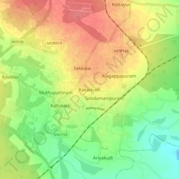
Nom : Carte topographique Karaikudi, altitude, relief.
Lieu : Karaikudi, Karaikkudi, Sivagangai, Tamil Nadu, 623001, India (9.91284 78.61952 10.23284 78.93952)
Altitude moyenne : 75 m
Altitude minimum : 26 m
Altitude maximum : 161 m
Faire un don
Équipez-vous pour votre prochaine aventure :
En tant que Partenaire Amazon, ce site perçoit une commission sur les achats éligibles sans surcoût pour vous.