
Carte topographique Wheatley
Carte interactive
Cliquez sur la carte pour afficher l’altitude.
À propos de cette carte
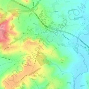
Nom : Carte topographique Wheatley, altitude, relief.
Altitude moyenne : 90 m
Altitude minimum : 52 m
Altitude maximum : 157 m
Autres cartes topographiques
Cliquez sur une carte pour visualiser sa topographie, son altitude et son relief.
Didcot
United Kingdom > England > Oxfordshire > South Oxfordshire > East Hagbourne
Didcot, East Hagbourne, South Oxfordshire, Oxfordshire, England, United Kingdom
Altitude moyenne : 61 m
Thame
United Kingdom > England > Oxfordshire > South Oxfordshire
Thame, South Oxfordshire, Oxfordshire, England, United Kingdom
Altitude moyenne : 74 m
Stadhampton
United Kingdom > England > Oxfordshire > South Oxfordshire
Stadhampton, South Oxfordshire, Oxfordshire, England, United Kingdom
Altitude moyenne : 61 m