
Carte topographique Mandern
Carte interactive
Cliquez sur la carte pour afficher l’altitude.
À propos de cette carte
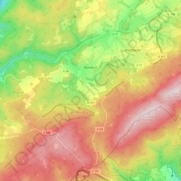
Nom : Carte topographique Mandern, altitude, relief.
Altitude moyenne : 525 m
Altitude minimum : 317 m
Altitude maximum : 701 m
Mandern liegt in der Nähe der Bundesstraße 407 (Hunsrückhöhenstraße).
Autres cartes topographiques
Cliquez sur une carte pour visualiser sa topographie, son altitude et son relief.
Klüsserath
Deutschland > Rheinland-Pfalz > Landkreis Trier-Saarburg
Klüsserath, Schweich an der Römischen Weinstraße, Landkreis Trier-Saarburg, Rheinland-Pfalz, Deutschland
Altitude moyenne : 227 m
Schöndorf
Deutschland > Rheinland-Pfalz > Landkreis Trier-Saarburg
Schöndorf, Ruwer, Landkreis Trier-Saarburg, Rheinland-Pfalz, Deutschland
Altitude moyenne : 390 m
Kell am See
Deutschland > Rheinland-Pfalz > Landkreis Trier-Saarburg
Kell am See, Saarburg-Kell, Landkreis Trier-Saarburg, Rheinland-Pfalz, 54427, Deutschland
Altitude moyenne : 521 m
Kanzem
Deutschland > Rheinland-Pfalz > Landkreis Trier-Saarburg
Kanzem, Konz, Landkreis Trier-Saarburg, Rheinland-Pfalz, Deutschland
Altitude moyenne : 177 m
Oberzerf
Deutschland > Rheinland-Pfalz > Landkreis Trier-Saarburg
Oberzerf, Zerf, Saarburg-Kell, Landkreis Trier-Saarburg, Rheinland-Pfalz, 54314, Deutschland
Altitude moyenne : 439 m
Aach
Deutschland > Rheinland-Pfalz > Landkreis Trier-Saarburg
Aach, Trier-Land, Landkreis Trier-Saarburg, Rheinland-Pfalz, Deutschland
Altitude moyenne : 340 m
Baldringen
Deutschland > Rheinland-Pfalz > Landkreis Trier-Saarburg
Baldringen, Saarburg-Kell, Landkreis Trier-Saarburg, Rheinland-Pfalz, Deutschland
Altitude moyenne : 425 m
Wellen
Deutschland > Rheinland-Pfalz > Landkreis Trier-Saarburg > Wellen
Wellen, Konz, Landkreis Trier-Saarburg, Rheinland-Pfalz, Deutschland
Altitude moyenne : 208 m
Beuren (Hochwald)
Deutschland > Rheinland-Pfalz > Landkreis Trier-Saarburg > Beuren (Hochwald)
Beuren (Hochwald), Hermeskeil, Landkreis Trier-Saarburg, Rheinland-Pfalz, Deutschland
Altitude moyenne : 479 m