
Carte topographique Yerres
Carte interactive
Cliquez sur la carte pour afficher l’altitude.
Yerres
La commune est implantée dans la basse vallée de l’Yerres, elle occupe les deux versants nord et sud, le point le plus bas de la commune est situé dans le lit de la rivière, à l’extrémité ouest de la Grande Prairie, près de la frontière avec Montgeron à seulement trente mètres d’altitude, le territoire s’élève ensuite rapidement vers le nord-est pour atteindre le point culminant sur le mont Griffon à cent seize mètres d’altitude à seulement neuf cent cinquante mètres de distance.
À propos de cette carte
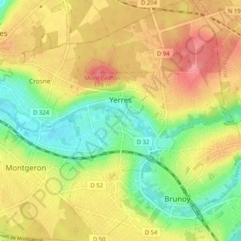
Nom : Carte topographique Yerres, altitude, relief.
Lieu : Yerres, Évry, Essonne, France métropolitaine, 91330, France (48.68983 2.46541 48.73586 2.52097)
Altitude moyenne : 74 m
Altitude minimum : 31 m
Altitude maximum : 117 m
Autres cartes topographiques
Cliquez sur une carte pour visualiser sa topographie, son altitude et son relief.
Bassin parisien
Le Bassin parisien présente un paysage sédimentaire composé de vastes plaines, de collines et de plateaux de basse altitude. La géomorphologie ainsi que la végétation varient avec la diversité des roches-mères sédimentaires : principalement des roches calcaires, des limons (placages de lœss), des…
Altitude moyenne : 126 m
Château de Villededon
France > Essonne > Saint-Pierre-du-Perray > Hameau de Villededon
Altitude moyenne : 86 m
Massy
France > Essonne > Massy > Massy
Massy est implantée à l’extrémité nord du plateau de Saclay, en bordure de la rivière la Bièvre. Le territoire s’étage entre une altitude de 110 mètres au sud - sud-ouest et 55 mètres au nord-ouest en suivant le cours de la rivière vers le nord. Le vieux Massy était ainsi installé dans une…
Altitude moyenne : 91 m
Juvisy-sur-Orge
France > Essonne > Juvisy-sur-Orge > Juvisy-sur-Orge
L’Institut national de l'information géographique et forestière attribue les coordonnées géographiques 48°41'33" Nord et 02°22'38" Est au point central de ce territoire. L’intégralité de sa frontière est avec la commune de Draveil est matérialisée par le cours de la Seine, sa vallée est…
Altitude moyenne : 66 m
Saint-Germain-lès-Arpajon
France > Essonne > Saint-Germain-lès-Arpajon > Saint-Germain-lès-Arpajon
Altitude moyenne : 77 m
Verrières-le-Buisson
France > Essonne > Verrières-le-Buisson > Verrières-le-Buisson
Positionnée sur le versant nord de la vallée de la Bièvre et sur l’extrémité sud du plateau de Villacoublay, la commune occupe un terrain relativement pentu dont le point culminant à cent soixante-quatorze mètres d’altitude est le deuxième plus haut du département.
Altitude moyenne : 106 m
Saint-Pierre-du-Perray
France > Essonne > Saint-Pierre-du-Perray > Saint-Pierre-du-Perray
Altitude moyenne : 75 m
Saint-Michel-sur-Orge
France > Essonne > Saint-Michel-sur-Orge > Saint-Michel-sur-Orge
Altitude moyenne : 81 m
Ancienne Ligne de Sceaux
France > Essonne > Boullay-les-Troux > Boullay-les-Troux
Altitude moyenne : 173 m
Puiselet-le-Marais
France > Essonne > Puiselet-le-Marais > Puiselet-le-Marais
Altitude moyenne : 119 m
Saulx-les-Chartreux
France > Essonne > Saulx-les-Chartreux > Saulx-les-Chartreux
Altitude moyenne : 85 m
Gometz-le-Châtel
France > Essonne > Gometz-le-Châtel > Gometz-le-Châtel
Le paysage communal est fortement marqué par la vallée du Vaularon. Le sud et l'ouest de Gometz-le-Châtel sont une plaine, à une altitude de 167,5 m. La commune se situe dans la pente de la vallée du Vaularon qui s'ouvre, au nord-est, sur la vallée de l'Yvette, et Bures-sur-Yvette.
Altitude moyenne : 147 m
Boutigny-sur-Essonne
France > Essonne > Boutigny-sur-Essonne > Boutigny-sur-Essonne
Altitude moyenne : 96 m
Draveil
France > Essonne > Draveil > Draveil
Draveil est située au nord-est du département de l’Essonne, totalement intégré à l’agglomération parisienne dans la région Île-de-France à la frontière est de la région naturelle de Brie française. La commune occupe un territoire de mille cinq cent soixante-quinze hectares approximativement…
Altitude moyenne : 64 m
Le Val-Saint-Germain
France > Essonne > Le Val-Saint-Germain > Le Val-Saint-Germain
Altitude moyenne : 118 m
Saint-Sulpice-de-Favières
France > Essonne > Saint-Sulpice-de-Favières > Saint-Sulpice-de-Favières
Altitude moyenne : 118 m
Janville-sur-Juine
France > Essonne > Janville-sur-Juine > Janville-sur-Juine
Altitude moyenne : 108 m
Auvers-Saint-Georges
France > Essonne > Auvers-Saint-Georges > Auvers-Saint-Georges
Le point le plus bas de la commune est situé à soixante-trois mètres d'altitude et le point culminant à cent cinquante-six mètres. La commune comporte un des sites de la réserve naturelle des sites géologiques de l'Essonne.
Altitude moyenne : 97 m
Boissy-sous-Saint-Yon
France > Essonne > Boissy-sous-Saint-Yon > Boissy-sous-Saint-Yon
Altitude moyenne : 113 m
Fontenay-lès-Briis
France > Essonne > Fontenay-lès-Briis > Fontenay-lès-Briis
Altitude moyenne : 127 m