
Carte topographique Bsharri
Carte interactive
Cliquez sur la carte pour afficher l’altitude.
À propos de cette carte
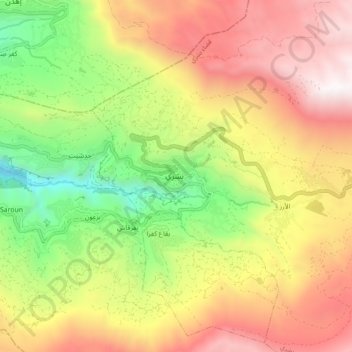
Nom : Carte topographique Bsharri, altitude, relief.
Lieu : Bsharri, Bsharri District, North Governorate, 1377, Lebanon (34.21043 35.97056 34.29043 36.05056)
Altitude moyenne : 1 855 m
Altitude minimum : 889 m
Altitude maximum : 2 831 m
Bsharri (Arabic: بشرّي Bšarrī; Syriac: ܒܫܪܝ; also Romanized Becharre, Bcharre, Bsharre, (Bcharre El Arez بشرّي الارز) is a town at an altitude of about 1,450 m (4,760 ft) to 3,088 m (10,131 ft). It is located in the Bsharri District of the North Governorate in Lebanon. Bsharri is the town of the only remaining and preserved original Cedars of God (Cedrus libani), and is the birthplace of the famous poet, painter and sculptor Khalil Gibran who now has a museum in the town to honour him. Moreover, Bsharri is home to Lebanon's oldest skiing area, the Cedars Ski Resort, and to the country's first ski lift, built in 1953. The resort is about a two-hour drive and 130 km (81 mi) from Beirut. Qurnat as Sawdā Mountain in Bsharri is the highest peak in the Levant, at 3,088 meters above sea level.