
Carte topographique Perito Moreno Glacier
Carte interactive
Cliquez sur la carte pour afficher l’altitude.
À propos de cette carte
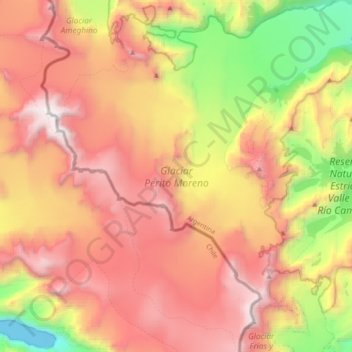
Nom : Carte topographique Perito Moreno Glacier, altitude, relief.
Altitude moyenne : 1 451 m
Altitude minimum : -3 m
Altitude maximum : 2 832 m
Occasionally, the glacial front does not completely obstruct the natural passage of water with an ice dam, but it approaches close enough to prevent water from passing freely, so without reaching elevation, an arm cut in Rico occurs. These events are classified as minor downloads. This is what happened in October 1996, when the Rico arm rose about a meter. At the end of that month the water pressure opened a greater passage in the walls of the glacial front and the discharge began, but slowly, since the passage had not been sufficiently open, so the maximum peak of the discharge flow occurred at the end of January with a value of 123 m³ / s, the dimensions being equalized on both sides only at the beginning of April.8 The events of 1994, 1995 and 1997 show similar behavior and magnitudes to those of 1996.
Autres cartes topographiques
Cliquez sur une carte pour visualiser sa topographie, son altitude et son relief.
Evita
Argentina > Santa Cruz Province > Río Gallegos
Evita, Río Gallegos, Güer Aike, Santa Cruz Province, Argentina
Altitude moyenne : 12 m
Puerto San Julián
Argentina > Santa Cruz Province
Puerto San Julián, Magallanes, Santa Cruz Province, Argentina
Altitude moyenne : 42 m
Mercado de la Ciudad
Argentina > Santa Cruz Province
Mercado de la Ciudad, Caleta Olivia, Deseado, Santa Cruz Province, Argentina
Altitude moyenne : 23 m
Costa del Sol
Argentina > Santa Cruz Province > Atlántico
Costa del Sol, Atlántico, Caleta Olivia, Deseado, Santa Cruz Province, Argentina
Altitude moyenne : 18 m
Laguna de los tres
Argentina > Santa Cruz Province
Laguna de los tres, Sendero al Fitz Roy, Lago Argentino, Santa Cruz Province, Argentina
Altitude moyenne : 1 083 m
Laguna del Carbón
Argentina > Santa Cruz Province
Laguna del Carbón, Corpen Aike, Santa Cruz Province, Argentina
Altitude moyenne : -102 m
Mesa
Argentina > Santa Cruz Province
Mesa, Lago Buenos Aires, Santa Cruz Province, Argentina
Altitude moyenne : 475 m
El Chaltén
Argentina > Santa Cruz Province
El Chaltén, Lago Argentino, Santa Cruz Province, Argentina
Altitude moyenne : 513 m
Atlántico
Argentina > Santa Cruz Province
Atlántico, Caleta Olivia, Deseado, Santa Cruz Province, Argentina
Altitude moyenne : 33 m
Corpen Aike
Argentina > Santa Cruz Province
Corpen Aike, Santa Cruz Province, Argentina
Altitude moyenne : 190 m
Magallanes
Argentina > Santa Cruz Province
Magallanes, Santa Cruz Province, Argentina
Altitude moyenne : 244 m
Río Gallegos
Argentina > Santa Cruz Province > Río Gallegos
Río Gallegos, Güer Aike, Santa Cruz Province, 9400, Argentina
Altitude moyenne : 13 m
Perito Moreno
Argentina > Santa Cruz Province
Perito Moreno, Lago Buenos Aires, Santa Cruz Province, Argentina
Altitude moyenne : 407 m
Río Turbio
Argentina > Santa Cruz Province
Río Turbio, Güer Aike, Santa Cruz Province, Argentina
Altitude moyenne : 421 m