
Carte topographique Quan Hóa District
Carte interactive
Cliquez sur la carte pour afficher l’altitude.
À propos de cette carte
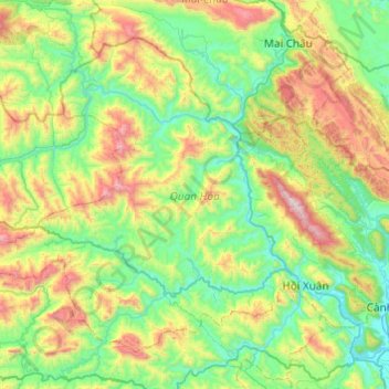
Nom : Carte topographique Quan Hóa District, altitude, relief.
Lieu : Quan Hóa District, Thanh Hoá Province, Vietnam (20.30259 104.70150 20.67067 105.18757)
Altitude moyenne : 489 m
Altitude minimum : 41 m
Altitude maximum : 1 630 m
Autres cartes topographiques
Cliquez sur une carte pour visualiser sa topographie, son altitude et son relief.
Ngọc Lặc District
Ngọc Lặc District, Thanh Hoá Province, Vietnam
Altitude moyenne : 104 m
Triệu Sơn District
Triệu Sơn District, Thanh Hoá Province, Vietnam
Altitude moyenne : 35 m
Hoằng Hóa District
Hoằng Hóa District, Thanh Hoá Province, 43000, Vietnam
Altitude moyenne : 8 m
Thạch Thành District
Thạch Thành District, Thanh Hoá Province, Vietnam
Altitude moyenne : 92 m
Ben Sung
Ben Sung, Như Thanh District, Thanh Hoa province, Vietnam
Altitude moyenne : 36 m
Thanh Hoá
Thanh Hoá, Thanh Hoá Province, 45000, Vietnam
Altitude moyenne : 6 m
Bưởi River
Vietnam > Thanh Hoa province > Vĩnh Lộc District > Vĩnh Lộc
Bưởi River, Vĩnh Lộc, Vĩnh Lộc District, Thanh Hoa province, Vietnam
Altitude moyenne : 29 m
Thôn Bảy
Vietnam > Thanh Hoa province > Nghi Sơn > Thôn Bảy
Thôn Bảy, Nghi Sơn, Thanh Hoa province, Vietnam
Altitude moyenne : 34 m