
Faire un don
Équipez-vous pour votre prochaine aventure :
En tant que Partenaire Amazon, ce site perçoit une commission sur les achats éligibles sans surcoût pour vous.
Carte topographique Mission Canyon
Cliquez sur la carte pour afficher l’altitude.
Faire un don
Équipez-vous pour votre prochaine aventure :
En tant que Partenaire Amazon, ce site perçoit une commission sur les achats éligibles sans surcoût pour vous.
Mission Canyon
The approximate center of Mission Canyon is located at 34°26′59″N 119°42′59″W / 34.44972°N 119.71639°W / 34.44972; -119.71639 (34.449797, -119.716315). Situated along the southern facing slopes of the Santa Ynez Mountains, Mission Canyon measures some 1,122 acres comprising an estimated 1,141 parcels primarily consisting of single-family residential development, recreational, open space, and agricultural land uses; but however lacks any commercial or industrial development. Non residential features include the Santa Barbara Botanic Garden, Rocky Nook County Park, the Santa Barbara Woman's Club, and the Santa Barbara County Fire Department Fire Station 15. The topography of the neighborhood varies from relatively flat areas located south of Foothill Road to greater slopes north of Foothill Road, ranging in elevations from approximately 300 ft (91 m) to just over 1,000 ft (305 m) above sea level.
Faire un don
Équipez-vous pour votre prochaine aventure :
En tant que Partenaire Amazon, ce site perçoit une commission sur les achats éligibles sans surcoût pour vous.
À propos de cette carte
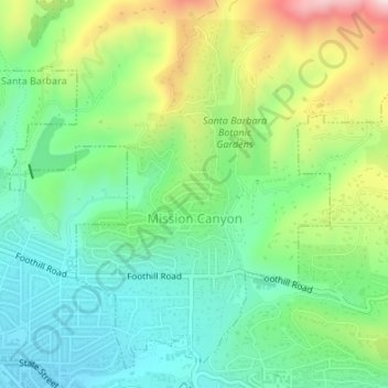
Nom : Carte topographique Mission Canyon, altitude, relief.
Altitude moyenne : 199 m
Altitude minimum : 69 m
Altitude maximum : 458 m
Faire un don
Équipez-vous pour votre prochaine aventure :
En tant que Partenaire Amazon, ce site perçoit une commission sur les achats éligibles sans surcoût pour vous.
Autres cartes topographiques
Cliquez sur une carte pour visualiser sa topographie, son altitude et son relief.
Solvang
United States > California > Santa Barbara County
Solvang is located at 34°35′38″N 120°8′23″W / 34.59389°N 120.13972°W / 34.59389; -120.13972. At an elevation of 505 ft (154 m), it lies in the Santa Ynez Valley some 46 miles (74 km) north-west of Santa Barbara and about 15 miles (24 km) north of the Pacific coast. According to the United…
Altitude moyenne : 194 m
Faire un don
Équipez-vous pour votre prochaine aventure :
En tant que Partenaire Amazon, ce site perçoit une commission sur les achats éligibles sans surcoût pour vous.
Faire un don
Équipez-vous pour votre prochaine aventure :
En tant que Partenaire Amazon, ce site perçoit une commission sur les achats éligibles sans surcoût pour vous.