
Carte topographique Shelburne
Carte interactive
Cliquez sur la carte pour afficher l’altitude.
À propos de cette carte
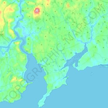
Nom : Carte topographique Shelburne, altitude, relief.
Lieu : Shelburne, Comté de Wexford, Leinster, Irlande (52.12275 -7.01781 52.35995 -6.76092)
Altitude moyenne : 31 m
Altitude minimum : -4 m
Altitude maximum : 265 m
Autres cartes topographiques
Cliquez sur une carte pour visualiser sa topographie, son altitude et son relief.
Enniscorthy
Enniscorthy, The Municipal District of Enniscorthy, Comté de Wexford, Leinster, Irlande
Altitude moyenne : 38 m
Glynn
Glynn, The Borough District of Wexford, Comté de Wexford, Leinster, Y35 CY80, Irlande
Altitude moyenne : 41 m
Bruce
Bruce, Ballygarrett ED, The Municipal District of Gorey — Kilmuckridge, Comté de Wexford, Leinster, Irlande
Altitude moyenne : 37 m
Lucas's Park
Lucas's Park, Enniscorthy Rural ED, The Municipal District of Enniscorthy, Comté de Wexford, Leinster, Irlande
Altitude moyenne : 31 m