
Faire un don
Équipez-vous pour votre prochaine aventure :
En tant que Partenaire Amazon, ce site perçoit une commission sur les achats éligibles sans surcoût pour vous.
Carte topographique Illingen
Cliquez sur la carte pour afficher l’altitude.
Faire un don
Équipez-vous pour votre prochaine aventure :
En tant que Partenaire Amazon, ce site perçoit une commission sur les achats éligibles sans surcoût pour vous.
Illingen
The municipality (Gemeinde) of Illingen is located at the eastern edge of the Enzkreis district, within the state of Baden-Württemberg and Federal Republic of Germany. It covers an area of 29.36 square kilometers (11.34 sq mi) that lies within the metropolitan areas of Karlsruhe and Pforzheim. Illingen is physically located on the Keuper Uplands, just north of the Enz valley, between the Neckar basin [de] and the hilly Stromberg region. The largest watercourses within the municipality are the Schmiebach and Metter rivers. The lowest elevation in the municipality, 208 meters (682 ft) NN, lies along the Schmie while the highest, 395 meters (1,296 ft) NN, is the top of the Burgberg in the west.
Faire un don
Équipez-vous pour votre prochaine aventure :
En tant que Partenaire Amazon, ce site perçoit une commission sur les achats éligibles sans surcoût pour vous.
À propos de cette carte
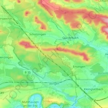
Nom : Carte topographique Illingen, altitude, relief.
Lieu : Illingen, Enzkreis, Baden-Württemberg, 75428, Germany (48.93638 8.86926 49.02132 8.94922)
Altitude moyenne : 279 m
Altitude minimum : 202 m
Altitude maximum : 437 m
Faire un don
Équipez-vous pour votre prochaine aventure :
En tant que Partenaire Amazon, ce site perçoit une commission sur les achats éligibles sans surcoût pour vous.
Autres cartes topographiques
Cliquez sur une carte pour visualiser sa topographie, son altitude et son relief.
Holzbachtal
Germany > Baden-Württemberg > Enzkreis > Straubenhardt > Langenalb
Altitude moyenne : 449 m
Faire un don
Équipez-vous pour votre prochaine aventure :
En tant que Partenaire Amazon, ce site perçoit une commission sur les achats éligibles sans surcoût pour vous.