
Carte topographique Hamiltons Bawn
Carte interactive
Cliquez sur la carte pour afficher l’altitude.
À propos de cette carte
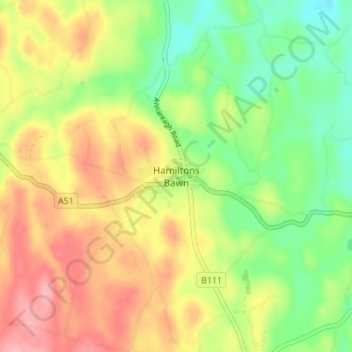
Nom : Carte topographique Hamiltons Bawn, altitude, relief.
Altitude moyenne : 101 m
Altitude minimum : 49 m
Altitude maximum : 158 m
Autres cartes topographiques
Cliquez sur une carte pour visualiser sa topographie, son altitude et son relief.
Portadown
United Kingdom > Northern Ireland > County Armagh
Portadown, County Armagh, Northern Ireland, BT62 1BF, United Kingdom
Altitude moyenne : 28 m
Armagh
United Kingdom > Northern Ireland > County Armagh > Milford
Armagh, Milford, County Armagh, Ulster, Northern Ireland, United Kingdom
Altitude moyenne : 100 m
Seafin
United Kingdom > Northern Ireland > County Armagh
Seafin, County Armagh, Ulster, Northern Ireland, United Kingdom
Altitude moyenne : 161 m
Newtownhamilton
United Kingdom > Northern Ireland > County Armagh
Newtownhamilton, County Armagh, Ulster, Northern Ireland, BT35 0PB, United Kingdom
Altitude moyenne : 222 m
Maghery
United Kingdom > Northern Ireland > County Armagh
Maghery, County Armagh, Ulster, Northern Ireland, BT71 6PA, United Kingdom
Altitude moyenne : 14 m
Navan Fort
United Kingdom > Northern Ireland > County Armagh > Armagh
Navan Fort, Navan Fort Road, Armagh, County Armagh, Northern Ireland, B1604BD, United Kingdom
Altitude moyenne : 54 m
Meigh
United Kingdom > Northern Ireland > County Armagh > Meigh
Meigh, County Armagh, Northern Ireland, BT35 8GN, United Kingdom
Altitude moyenne : 139 m
Jonesborough
United Kingdom > Northern Ireland > County Armagh > Jonesborough
Jonesborough, County Armagh, Northern Ireland, BT35 8HR, United Kingdom
Altitude moyenne : 130 m