
Carte topographique Yale
Carte interactive
Cliquez sur la carte pour afficher l’altitude.
À propos de cette carte
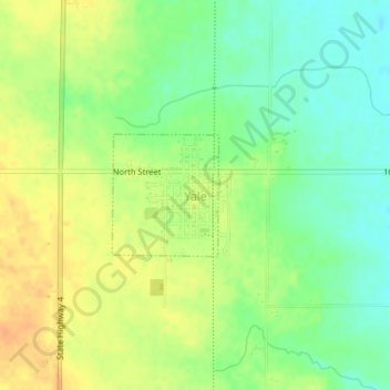
Nom : Carte topographique Yale, altitude, relief.
Lieu : Yale, Guthrie County, Iowa, United States (41.77089 -94.36275 41.77936 -94.35284)
Altitude moyenne : 338 m
Altitude minimum : 321 m
Altitude maximum : 355 m
Autres cartes topographiques
Cliquez sur une carte pour visualiser sa topographie, son altitude et son relief.
Panora
United States > Iowa > Guthrie County
Panora, Guthrie County, Iowa, United States
Altitude moyenne : 327 m
Bagley
United States > Iowa > Guthrie County
Bagley, Guthrie County, Iowa, United States
Altitude moyenne : 335 m
Bayard
United States > Iowa > Guthrie County
Bayard, Guthrie County, Iowa, United States
Altitude moyenne : 343 m
Menlo
United States > Iowa > Guthrie County
Menlo, Guthrie County, Iowa, 50164, United States
Altitude moyenne : 378 m
City of Coon Rapids
United States > Iowa > Guthrie County
City of Coon Rapids, Guthrie County, Iowa, United States
Altitude moyenne : 337 m
Adair/Finnegan Dam
United States > Iowa > Guthrie County
Adair/Finnegan Dam, Guthrie County, Iowa, United States
Altitude moyenne : 347 m
Jamaica
United States > Iowa > Guthrie County
Jamaica, Guthrie County, Iowa, United States
Altitude moyenne : 317 m
Guthrie Center
United States > Iowa > Guthrie County
Guthrie Center, Guthrie County, Iowa, United States
Altitude moyenne : 347 m
Lake Panorama
United States > Iowa > Guthrie County
Lake Panorama, Guthrie County, Iowa, United States
Altitude moyenne : 348 m
City of Coon Rapids
United States > Iowa > Guthrie County
City of Coon Rapids, Guthrie County, Iowa, United States
Altitude moyenne : 345 m
Casey
United States > Iowa > Guthrie County
Casey, Guthrie County, Iowa, United States
Altitude moyenne : 389 m