
Carte topographique Jinhae-gu
Carte interactive
Cliquez sur la carte pour afficher l’altitude.
À propos de cette carte
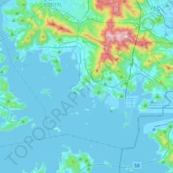
Nom : Carte topographique Jinhae-gu, altitude, relief.
Lieu : Jinhae-gu, Changwon-si, South Gyeongsang, South Korea (35.03591 128.59931 35.18023 128.84335)
Altitude moyenne : 82 m
Altitude minimum : -8 m
Altitude maximum : 780 m
Autres cartes topographiques
Cliquez sur une carte pour visualiser sa topographie, son altitude et son relief.
Pyeong-am-ri
Pyeong-am-ri, Changwon-si, South Gyeongsang, South Korea
Altitude moyenne : 350 m
Masanhappo-gu
Masanhappo-gu, Changwon-si, South Gyeongsang, South Korea
Altitude moyenne : 92 m