
Carte topographique Parroquia San Antonio de los Altos
Carte interactive
Cliquez sur la carte pour afficher l’altitude.
Parroquia San Antonio de los Altos
San Antonio de los Altos is part of the Altos Mirandinos Metropolitan Area, which is, in itself part of the Metropolitan Region of Caracas. It covers an area of about 55 km2 (21 sq mi) and has an average altitude of 1,300 metres (4,300 ft) above sea level. San Antonio is the highest point in the Altos Mirandinos area.
À propos de cette carte
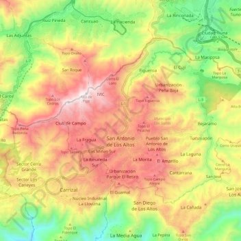
Nom : Carte topographique Parroquia San Antonio de los Altos, altitude, relief.
Altitude moyenne : 1 240 m
Altitude minimum : 736 m
Altitude maximum : 1 727 m