
Faire un don
Équipez-vous pour votre prochaine aventure :
En tant que Partenaire Amazon, ce site perçoit une commission sur les achats éligibles sans surcoût pour vous.
Carte topographique Calanca
Cliquez sur la carte pour afficher l’altitude.
Faire un don
Équipez-vous pour votre prochaine aventure :
En tant que Partenaire Amazon, ce site perçoit une commission sur les achats éligibles sans surcoût pour vous.
À propos de cette carte
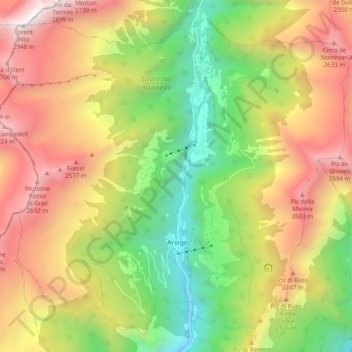
Nom : Carte topographique Calanca, altitude, relief.
Lieu : Calanca, Moësa, Graubünden, 6543, Schweiz (46.28415 9.06431 46.34515 9.16219)
Altitude moyenne : 1 757 m
Altitude minimum : 740 m
Altitude maximum : 2 913 m
Faire un don
Équipez-vous pour votre prochaine aventure :
En tant que Partenaire Amazon, ce site perçoit une commission sur les achats éligibles sans surcoût pour vous.
Autres cartes topographiques
Cliquez sur une carte pour visualiser sa topographie, son altitude et son relief.
Braggio
Schweiz > Graubünden > Moësa > Calanca > Arvigo
Der Ort liegt auf einer Terrasse 500 Höhenmeter linksseitig über dem Talgrund des Calancatals. Vom gesamten ehemaligen Gemeindegebiet von 688 ha sind 462 ha von Wald und Gehölz bedeckt. Weitere 154 ha sind unproduktive Fläche (meist Gebirge), 66 ha landwirtschaftliche Nutzfläche und 6 ha Siedlungsfläche.
Altitude moyenne : 1 521 m
San-Bernardino-Pass
Schweiz > Graubünden > Moësa > Misox
San-Bernardino-Pass: Passhöhe mit Hospiz
Altitude moyenne : 2 134 m
Faire un don
Équipez-vous pour votre prochaine aventure :
En tant que Partenaire Amazon, ce site perçoit une commission sur les achats éligibles sans surcoût pour vous.