
Carte topographique Simbach
Carte interactive
Cliquez sur la carte pour afficher l’altitude.
À propos de cette carte
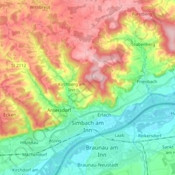
Nom : Carte topographique Simbach, altitude, relief.
Lieu : Simbach, Landkreis Rottal-Inn, Bavaria, 84359, Germany (48.25305 12.94150 48.32081 13.08112)
Altitude moyenne : 425 m
Altitude minimum : 333 m
Altitude maximum : 555 m
Autres cartes topographiques
Cliquez sur une carte pour visualiser sa topographie, son altitude et son relief.
Niederndorf
Germany > Bavaria > Landkreis Rottal-Inn > Eggenfelden
Niederndorf, Eggenfelden, Landkreis Rottal-Inn, Bavaria, 84307, Germany
Altitude moyenne : 430 m
Pfarrkirchen
Germany > Bavaria > Landkreis Rottal-Inn
Pfarrkirchen, Landkreis Rottal-Inn, Bavaria, 84347, Germany
Altitude moyenne : 429 m