
Carte topographique Kings
Carte interactive
Cliquez sur la carte pour afficher l’altitude.
À propos de cette carte
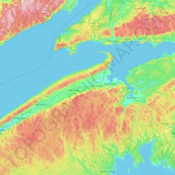
Nom : Carte topographique Kings, altitude, relief.
Lieu : Kings, Kings County, Nueva Escocia, B4R 1A2, Canadá (44.42053 -65.23458 45.70053 -63.95458)
Altitude moyenne : 99 m
Altitude minimum : -3 m
Altitude maximum : 407 m
Autres cartes topographiques
Cliquez sur une carte pour visualiser sa topographie, son altitude et son relief.
Lakelands
Canadá > Nueva Escocia > Lakelands
Lakelands, Municipality of the County of Cumberland, Cumberland County, Nueva Escocia, B0M 1S0, Canadá
Altitude moyenne : 146 m
Seabright
Canadá > Nueva Escocia > Seabright
Seabright, Halifax Regional Municipality, Halifax County, Nueva Escocia, Canadá
Altitude moyenne : 27 m
Isla de Cabo Bretón
Canadá > Nueva Escocia > Margaree Valley
Isla de Cabo Bretón, Margaree Valley, Municipality of the County of Inverness, Inverness County, Nueva Escocia, Canadá
Altitude moyenne : 66 m
Indian Lake
Canadá > Nueva Escocia > Indian Lake
Indian Lake, Municipality of Pictou County, Pictou County, Nueva Escocia, Canadá
Altitude moyenne : 211 m