
Carte topographique 磯谷郡
Carte interactive
Cliquez sur la carte pour afficher l’altitude.
À propos de cette carte
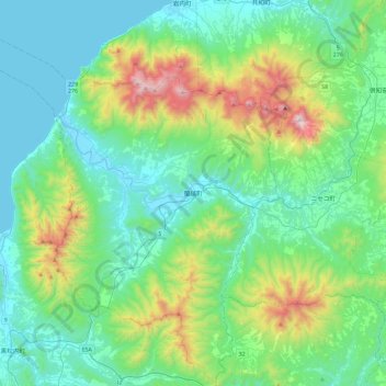
Nom : Carte topographique 磯谷郡, altitude, relief.
Lieu : 蘭越町, 磯谷郡, 後志総合振興局, Prefectura de Hokkaidō, 北海道地方, Japón (42.63541 140.19549 42.98180 140.64325)
Altitude moyenne : 275 m
Altitude minimum : -2 m
Altitude maximum : 1 294 m
Autres cartes topographiques
Cliquez sur une carte pour visualiser sa topographie, son altitude et son relief.